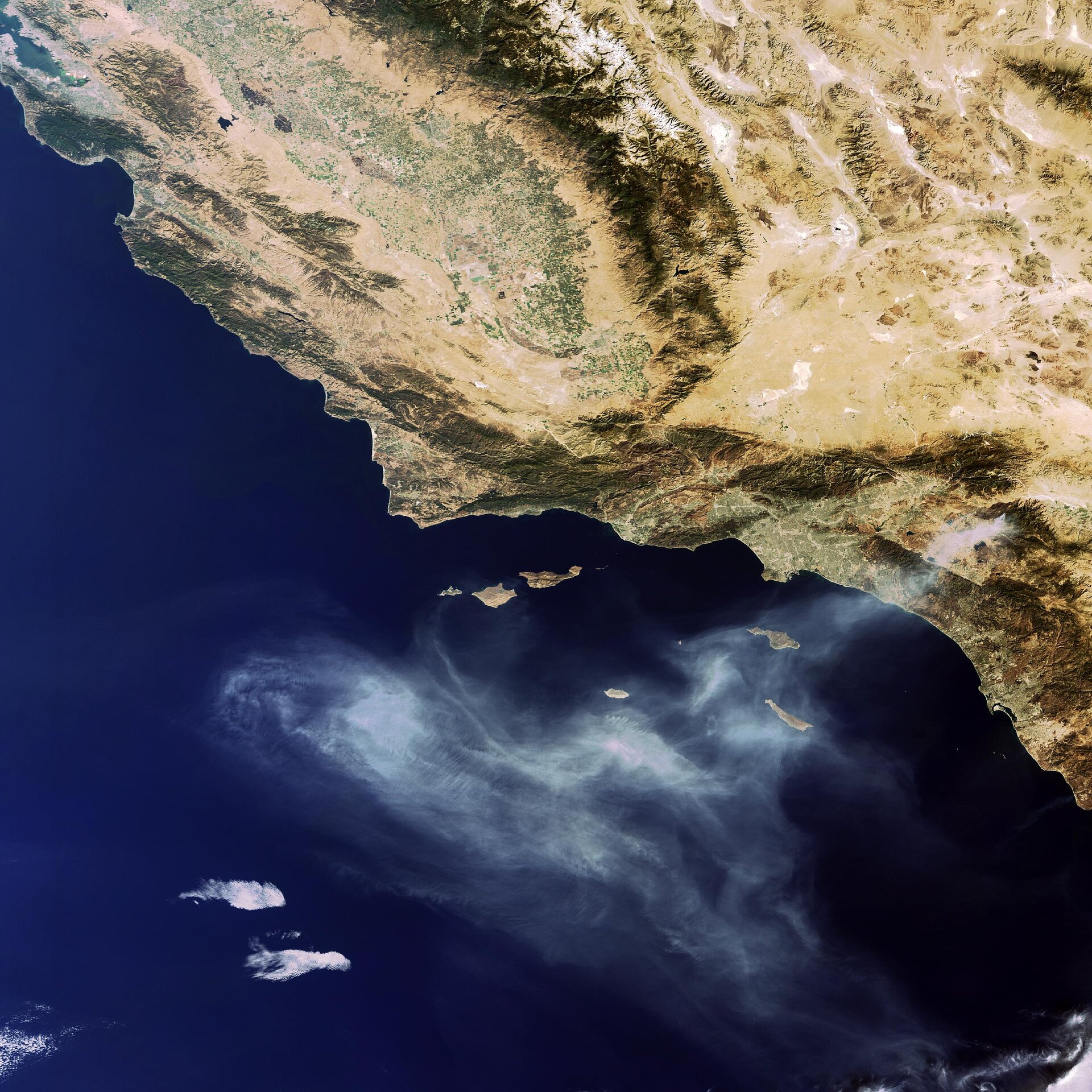
Earth from Space: California’s ‘Esperanza’ fire
This Envisat image taken on 27 October 2006 captures the fire in southern California that has claimed the lives of five firefighters and forced hundreds of people to evacuate their homes since it began last Thursday.
The blaze, called ‘Esperanza’ as major fires in California are given names, burned some 163 square kilometres about 144 kilometres east of the city of Los Angeles before firefighters contained it on Monday.
Four U.S. Forest Service firefighters were killed on Thursday when winds suddenly shifted causing flames to overcome them as they tried to protect homes. A fifth firefighter was burned on over 90 percent of his body in the same incident; he died on Tuesday.
California authorities have said the fire was set deliberately and have offered a $500 000 (€392 000) reward for information leading to an arrest. The Associated Press quoted the California Department of Forestry saying the firefighting costs have reached $9.9 million
Major fires are visible from space – satellites detect not only the smoke billowing from major conflagrations but also the burn scars left in their wake and even the fires themselves – appearing as 'hotspots' when scanning the Earth's surface in infrared wavelengths.
For a decade now, ESA satellites have been continuously surveying fires burning across the Earth’s surface. Worldwide fire maps based on this data are now available to users online in near-real time through ESA's ATSR World Fire Atlas (WFA). The WFA data are based on results from the Along Track Scanning Radiometer (ATSR) instrument onboard ESA’s ERS-2 satellite and the Advanced Along Track Scanning Radiometer (AATSR) onboard Envisat. These twin radiometer sensors work like thermometers in the sky, measuring thermal infrared radiation to take the temperature of Earth's land surfaces.
Temperatures exceeding 312º K (38.85 ºC) are classed as burning fires by ATSR/AATSR, which are capable of detecting fires as small as gas flares from industrial sites because of their high temperature. Fires are detected best during local night, when the surrounding land is cooler.
This Envisat image was acquired by the Medium Resolution Imaging Spectrometer (MERIS) instrument while working in Full Resolution mode to provide a spatial resolution of 300 metres.