Europe celebrates its first Maritime Day
The first-ever ‘European Maritime Day’ is being celebrated across Europe today to highlight the crucial role oceans and seas play in the everyday lives of EU citizens and to raise awareness of the opportunities and challenges facing the sector.
With nearly 70 000 km of coastline, two oceans and four seas, Europe’s maritime policy is key to safeguarding ocean ecosystems and coastal regions while at the same time ensuring maritime and coastal economies. Addressing these competing challenges, the European Commission (EC) adopted an Integrated Maritime Policy for the EU last October.
Under the European Space Policy, ESA is responsible for implementing space capabilities that respond to EU policy needs. The Integrated Maritime Policy facilitates efficient exploitation of space systems in the maritime sector, which ESA has been actively involved in over the last 25 years.
ESA’s ERS-1, ERS-2 and Envisat satellites have been the main vehicles for testing and demonstrating the feasibility of using satellite Earth observation (EO) data in different maritime policy areas, such as Arctic monitoring, marine environment protection, maritime border control, coastal planning and marine research.
Arctic monitoring
Since 2003, Envisat’s Advanced Synthetic Aperture Radar (ASAR) instrument has been used to detect icebergs in the North Atlantic to support offshore oil production and the International Ice Patrol, which is responsible for routine surveillance of the North Atlantic shipping lanes to ensure the risk of collisions with icebergs is minimised.
In addition, Envisat and Radarsat data are used on an operational basis by national ice services for the production of ice information charts to shipping operators, which aids intra-European transport in the winter months when the Baltic freezes.
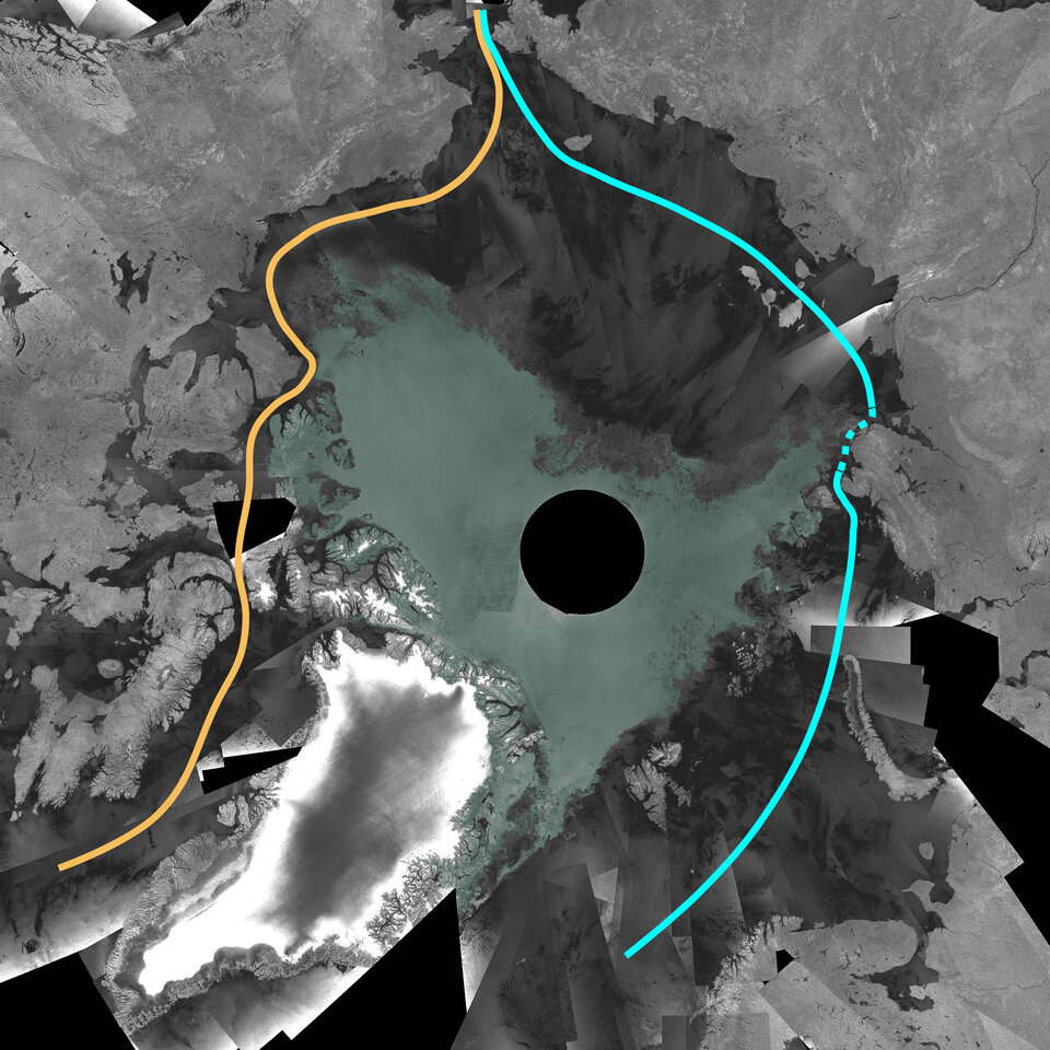
Recently, the Arctic ice edge retreats during the summer months and the North East passage through the Kara and Laptev Seas to China and Japan is becoming a viable transport route, creating a need for routine monitoring of sea ice conditions in these areas to ensure safe transit.
In such situations, Envisat has repeatedly demonstrated the cost effectiveness of satellite imagery within the operational monitoring system.
Marine environment protection

In 2002, Envisat’s ASAR sensor acquired images revealing the extent of the Prestige oil spill in Spain. Envisat and ERS-2 imagery were then made available to aid with international clean-up efforts, including characterising areas expected to suffer first from beaching of the oil.
Since then, ESA has been working within the Global Monitoring for Environment and Security (GMES) Services Element (GSE) to demonstrate and qualify the capacity for pan-European oil spill surveillance.
In 2006, an operational satellite-based oil slick detection service based on SAR data from Envisat and the Canadian Radarsat satellite was set up for all European waters under the European Maritime Safety Agency (EMSA). The service, named CleanSeaNet, provides notification of a pollution event within 20 to 30 minutes of the satellite overpass.
By integrating the SAR oil slick information with vessel information, it becomes possible to identify potentially responsible vessels.
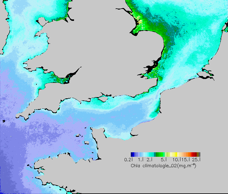
Routine monitoring of water quality in European coastal areas is important to effectively protect fragile coastal ecosystems and ensure safe exploitation of coastal waters for fish farming, leisure and transportation.

Within the ESA GSE MARCOAST project, national and regional environmental protection agencies are routinely provided with ocean colour-based water quality parameters, including chlorophyll-a concentration, transparency and suspended sediment load as well as the timely detection of algal blooms, for integration into their operational monitoring practices.
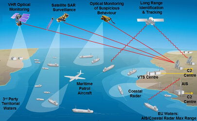
Maritime border control
European states are under increasing responsibility to effectively control, protect and manage their territorial waters and exclusive economic zones. In addition to monitoring their own fishing zones, they are faced with countering illegal trafficking of persons, drugs and weapons.
The MARISS project financed under GSE is working with police, border guards, coast guards, intelligence services and national navies as well as European and international agencies in order to test the integration of different EO data sets and amenable European states to extend their integrated surveillance to areas beyond the range of traditional systems.
Coastal planning and management
Coastal zones are important environmental and economic resources that face threats to their future, such as water pollution and eroding shorelines.
Space-based instruments can pinpoint wilderness areas under threat from over-developments of coastal zones and enable a sustainable pattern of development. Satellites can also track the process of coastal erosion as it happens, and the long-term rate of loss can be estimated with years of archived data.
Marine research

EO provides unprecedented measurements over all ocean areas, enabling researchers to characterise physical, chemical and biological processes at a level of detail and for time periods that were previously not feasible.
For instance, accurate measurements of sea surface height variation by the radar altimeter instrument have provided a unique capability to monitor variations in currents at the regional level. The Along Track Scanning Radiometer (AATSR) series of instruments have delivered a highly accurate time series of sea surface temperature variations over a 17-year period, which has enabled a unique characterisation of global warming during this time.
In addition, satellite data from the radar altimeters onboard ERS-1, ERS-2 and Envisat and NASA/CNES’ Topex-Poseidon have detected a trend in sea level rise between 2.64 and 3.29 mm/year over the last 15 years.
These capabilities are all based on EO satellites that have been in operation for some time, and ESA is working to ensure continuity of these key data streams within the framework of GMES with its upcoming Sentinel and Earth Explorer missions.