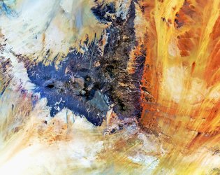
• → European Space Agency

      • Space for Europe
      • Space News
      • Space in Images
      • Space in Videos
    • About Us

      • Welcome to ESA
      • DG’s blog
      • For Member State Delegations
      • Business with ESA
      • Law at ESA
      • ESA Exhibitions
      • ESA Publications
      • Careers at ESA
      • ESAshop
    • Our Activities

      • Space News
      • Observing the Earth
      • Human and Robotic Exploration
      • Space Transportation
      • Navigation
      • Space Science
      • Space Engineering & Technology
      • Operations
      • Telecommunications & Integrated Applications
      • Preparing for the Future
    • Careers at ESA

    • For Media

      • Media
      • ESA TV
      • Videos for professionals
      • Photos
    • For Educators

    • For Kids

    • ESA

    • Space in Images

    ESA > Space in Images > 2018 > 05 > Emi Koussi

    Free Search (23844 images)

    Emi Koussi

    (7.44 MB)

    (406.29 MB)

    Details

    Open/Close
    • Title Emi Koussi
    • Released 04/05/2018 10:00 am
    • Copyright contains modified Copernicus Sentinel data (2017), processed by ESA, CC BY-SA 3.0 IGO
    • Description

      Reminiscent of an artist’s pallet, this is the Emi Koussi volcano in northern Chad, imaged by the Copernicus Sentinel-2B satellite.

      Emi Koussi lies at the southeast end of the Tibesti Mountains. At almost 3500 m, this pyroclastic shield volcano rises high above the surrounding sandstone plains. It is not only the highest mountain in Chad, but also the highest in the Sahara. Calderas, or depressions, can be seen nestling in the cap of the volcano. These are a result of magma erupting quickly and the surface collapsing into the partially emptied magma chamber.  Emi Koussi is extinct and it is not known when it last erupted.

      The lack of vegetation allows wind and water to carve long grooves in the rock. These grooves can be 30 metres deep and several kilometres long.

      The Copernicus Sentinel-2 satellites carry innovative high-resolution multispectral cameras with 13 spectral bands. Processing the image here reveals differences in the minerals of the rock. For example, the green around the cone of the volcano is old lava, while sandstone in the surrounding area appear in reds and yellows.

      This image, which was captured on 27 November 2017, is also featured on the Earth from Space video programme.

    • Id 393723

    TAGS

    Open/Close
    • Click on the tags to find the matching images.
    • Activity Observing the Earth
    • Mission Sentinel-2
    • System Copernicus
    • Location Chad
    • Set Earth observation image of the week

    TAGS

    Open/Close

    Details

    Open/Close

    Rate this

    Views

    Comments

    Share

    • Currently 5 out of 5 Stars.
    • 1
    • 2
    • 3
    • 4
    • 5

    Rating: 4.9/5 (74 votes cast)

    Thank you for rating!

    You have already rated this page, you can only rate it once!

    Your rating has been changed, thanks for rating!

    4181 0
    Tweet

    COMMENTS

    Open/Close

    COMMENTS

    Open/Close

    RELATED IMAGES

    • Tibesti Mountains 16 November 2012 Tibesti Mountains 7725 Votes: 40
    • 28 July 2015 Uluru/Ayers Rock 1871 Votes: 10

    Related links

    • Image of the week archive

    • Earth observation

    USING OUR IMAGES

    Terms and conditions

    Contact us

    Commenting guidelines

    • Connect with us
    • Subscribe
    • mobile version
    • FAQ

    • Site Map

    • Contacts

    • Terms and conditions