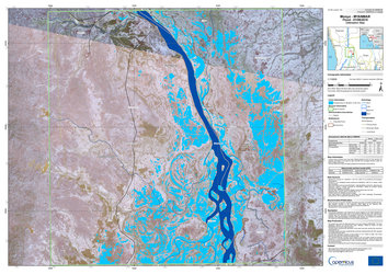
Irrawaddy River, Myanmar
The powerful 7.7-magnitude earthquake that struck central Myanmar on March 28 has claimed thousands of lives and left thousands more injured. In neighbouring Thailand, people are also known to have died and thousands have had to be evacuated from buildings in Bangkok.
In response to the disaster, the Copernicus Emergency Management Service and the International Charter Space and Major Disasters have both been activated to provide satellite imagery to help relief efforts.
The image from 30 March from the Copernicus Sentinel-2 mission provides a broad view of the area around the Irrawaddy River. It indicates the location featured in an animation, linked here, which reveals a distinct north-south rupture in the ground west of the Irrawaddy River, near Mandalay.