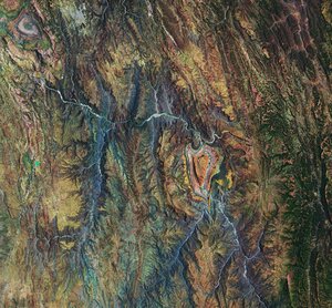
Bolivian forest and landscape from Biomass
ESA revealed the first stunning images from its groundbreaking Biomass satellite mission – marking a major leap forward in our ability to understand how Earth’s forests are changing and exactly how they contribute to the global carbon cycle.
This image features part of Bolivia. Bolivia has experienced significant deforestation, ranking among the highest globally for primary forest loss. Although there are complex reasons at play, this is primarily driven by forest clearance for agricultural expansion. Over time, the Biomass mission will be used to determine how carbon stocks stored in this kind of forest are changing.
This vibrant image was created using the radar instrument’s different polarisation channels, with each colour revealing distinct characteristics of the landscape. For instance, green hues mainly represent rainforest, red hues forested floodplains and wetlands, and blue–purple is indicative of grasslands, while black areas are rivers and lakes.
The image spans approximately 90 km along the Biomass satellite's flight path (length) and 60 km across in width, with north oriented to the right.
The Biomass synthetic aperture operates continuously in fully polarimetric imaging mode, capturing all four linear polarisation combination: HH, HV, VH, and VV. The resulting images are displayed using a Pauli decomposition in RGB format, where different scattering mechanisms are represented by specific colours: blue corresponds to single-bounce surface scattering, red to double-bounce scattering, and green to multiple-bounce interactions, which are indicative of volume scattering within the forest canopy.
Read full story: Biomass satellite returns striking first images of forests and more