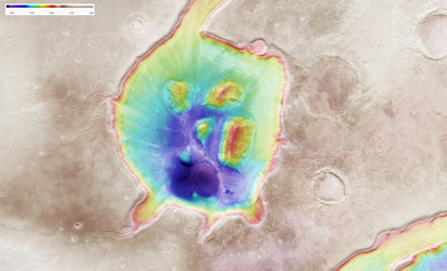
Topographic map of Mamers Valles on Mars
This colour-coded topographic image shows part of Mamers Valles, a huge valley system in Mars’s northern hemisphere.
It was created from data collected by ESA’s Mars Express on 7 December 2024 (orbit 26423) and is based on a digital terrain model of the region, from which the topography of the landscape can be derived. Lower parts of the surface are shown in green tones, while higher altitude regions show up in whites and reds, as indicated on the scale to the top right.
North is to the right. The ground resolution of the original image is approximately 20 m/pixel and the image is centred at about 45°N/17°E.
[Image description: A brightly coloured patch of Mars, with an area of lower land running between the left and centre of the frame. Large islands dot the lower land, and steep cliffs appear to divide the lower and higher land. A colour scale bar indicates that blue-green colours are lowest altitude, red-white-brown colours are highest altitude, and yellow-orange are in the middle.]