EarthCARE distinguishes volcanic aerosols
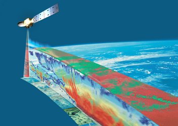
When Anak Krakatau erupted earlier this month, the European Space Agency’s EarthCARE satellite, orbiting above, captured vertical profiles of different constituents within the volcanic plume. Designed primarily to advance our understanding of how clouds and aerosols influence Earth’s climate, here EarthCARE also provided valuable information to support safe air travel. At the same time, these observations offer new insights into the impact that volcanic eruptions have on the climate system.
This image uses a capture from Copernicus Sentinel-3 on 5 September overlaid with data from EarthCARE’s MSI, ATLID and CPR instruments. The image also notes aircraft flight levels: most aircraft cruise around FL350, which means 35,000 ft (about 10,700 m).
The swath from the MSI instrument shows the volcanic plume in false colour, with purple areas highlighting ash, and bright green indicating sulphur dioxide gas.
Above the MSI swath, the vertical curtain shows a range of different types of aerosols measured by ATLID and by the CPR. These aerosol types are spread in layers of optically thin and thick sulphate, fine ash, and a distinct feature of what is thought to be coarse ash (dark brown).
The area shaded in grey is a region where ATLID’s laser beam cannot penetrate through the optically thick layer of sulphate particles (orange) above, and where CPR lacks sensitivity to fine ash.
Another interesting feature of the ATLID profile is that there is a low-altitude layer of aerosols extending beyond the region affected by the eruption. This is the atmosphere’s boundary layer, which likely contains smoke (very light brown) from wildfires burning in Sumatra.
Read full story: EarthCARE’s view of volcanic plume boosts air safety