Italy and beyond imaged by Sentinel-3C
Just two weeks after it was launched, the Copernicus Sentinel-3C satellite returned its first images and measurements from two of its key instruments – a major milestone that confirms the satellite is working well and on the road to monitoring the health of Earth’s oceans, land, cryosphere and atmosphere.
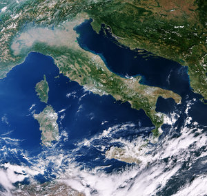
This first image, captured by the ocean and land colour instrument on 30 September, is a striking natural-colour view that reveals Italy in beautiful detail, stretching from southern Germany in the north to Sicily and the southern Mediterranean.
Just above the centre of the image, the broad, flat expanse of the Po Valley – Italy’s agricultural heartland – stands out in shades of brown and green. Just to the north, the snow-capped Alps form a dramatic contrast with the lowlands, their bright peaks clearly visible against the surrounding landscape. Across the rest of Italy, variations in green and brown reflect differences in vegetation, agriculture and other types of land cover.
To the east, the deep blue waters of the Adriatic Sea separate Italy from the Balkan Peninsula, which is partially visible in the image. Noticeable variations in sea colour can be seen along Italy’s eastern coastline, where lighter blue waters hug the shore. These brighter tones are likely caused by sediment carried into the sea by rivers and transported along the coast.
On Italy’s western side, the dark waters of the Tyrrhenian Sea surround the islands of Sardinia and Sicily, which are clearly visible, while Corsica is largely obscured by cloud. Together, the contrasting colours of the land, snow-covered mountains and surrounding seas provide a vivid view of Italy’s diverse landscape from space.
Read full story: Sentinel-3C returns its first views of Earth