|
Weather Foehn windInteractive MeteosatMeteosat imagesClimate African climateEl NiñoGulf StreamHimalayan climateExplore the world and its climate with JP ExplorerLake Chad |
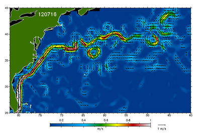
| The Gulf Stream IntroductionBackground The North Atlantic GyreExercises Exercise 1: Sea surface temperatureExercise 2: Sea surface heightExercise 3: EddiesEduspace - Software LEOWorks 4 (MacOS)LEOWorks 4 (Linux)LEOWorks 4 (Windows)Eduspace - Download GulfStream.zip | |||||||||||||||||||||||