| | | | |
 |
|
Inondations Thessalonique (Grèce)Tremblements de terre IntroductionTremblement de terre d'IzmitOuragans Ondes de tempêteL'ouragan KatrinaVolcans IntroductionCeinture volcanique andineEtnaNyiragongo et Nyamuragira
| | | | | | | | Article Images |  |
Exercice 3: Détection de la lave : cartes et images des événements - suite
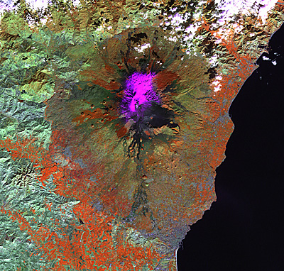
| The new lava stream of Mount Etna's 2001 eruption is visible in the FCC 4-5-3. At this stage most of the lava has already spread (but not all, the eruption lasted approximately until 9 August). Many dark coloured lava streams can be seen.
Credits: USGS | |  |  | |
| | | | | The new lava stream of the Mount Etna's 2001 eruption is visible in the band 6 image. At this stage, most of the lava has already spread (but not all, the eruption lasted until 9 August). The hot lava is still visible in band 6 (hot = white) although it is not distinguishable from others in mid-IR. In the 4-5-3 combination, many dark coloured lava streams can be seen, but only in band 6 can the new one be identified and distinguished from the other ones. Furthermore, the snow is clearly seen (cold = dark).
Credits: USGS | | | | |
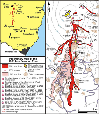
| | | | | Lava map of Etna's July-August 2001 eruption showing lava flows, fissures, and related features. In light pink, the 1983 lava flow field is displayed for comparison. The legend is also linked to numbers near the vents and fissures, as a way to indicate the sequence of activity. The sketch map is preliminary; it is a composite based on both fieldwork by Behnke and others, and already available maps appearing on the web, including those on the site of INGV-Sezione di Catania.
Credits: Boris Behnke and Marco Neri, INGV (Global Volcanism Program, http://www.volcano.si.edu/) | | | | |
| |
| | Etna IntroductionDétection des changements et évaluation des dangers Feuille de travailExercice 1 : Explorer le volcanExercice 2 : Interprétation visuelle au moyen de photographies terrestresExercice 3: Détection de la lave : cartes et images des événementsExercice 4 : Évaluation des dangers : l'utilité du SIGEduspace - Télécharger Etna_Landsat_GIS.zipEduspace - Logiciels LEOWorks 3LEOWorks 3 Tutorial
|