| | | | |
 |
|
Weather Foehn windInteractive MeteosatMeteosat imagesClimate African climateEl NiñoGulf StreamHimalayan climateExplore the world and its climate with JP ExplorerLake Chad
| | | | | | | Exercise 1: Visualisation of Lake Chad
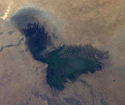
In order to be able to explore the area yourself, you are provided with an image, of Lake Chad (Envisat_MERIS_LakeChad_January2011) that can be found on the right side of this page.
The image was acquired by Envisat’s MERIS sensor, a programmable, medium resolution imaging spectrometer operating in the solar reflective spectral range. Fifteen spectral bands can be selected by ground command. This .tif file contains all 15 spectral bands (channels) of the sensor. The characteristics of each band/channel can be found in the table below:
| MERIS Channel Number | Centre Wavelength / Bandwidth (nm) | Application | | 1 | 412.5 (purple) / 10 | Yellow substance and detrial pigments | | 2 | 442.5 (blue) / 10 | Chlorophyll absorption maximum | | 3 | 490 (blue-cyan) / 10 | Chlorophyll and other pigments | | 4 | 510 (cyan-green) / 10 | Suspended sediment, red tides | | 5 | 560 (green) / 10 | Chlorophyll absorption minimum | | 6 | 620 (orange-red) / 10 | Suspended sediment | | 7 | 665 (red) / 10 | Chlorophyll absorption and fluorescence reference | | 8 | 681.25 (red) / 7.5 | Chlorophyll fluorescence peak | | 9 | 708.75 (NIR) / 10 | Fluorescence reference, atmospheric corrections | | 10 | 753.75 (NIR / 7.5 | Vegetation, cloud | | 11 | 760.625 (NIR) / 3.75 | Oxygen absorption R-branch | | 12 | 778.75 (NIR) / 15 | Atmosphere corrections | | 13 | 865 (NIR) / 20 | Vegetation, water vapour reference | | 14 | 885 (NIR) / 10 | Atmosphere corrections | | 15 | 900 (NIR) / 10 | Water vapour, land |
|
Open and inspect some of the different bands of the file. For instance, open both a red (e.g. channel 8) as well as a NIR (e.g. channel 13), and arrange them side by side.
Take a look at the description of their field of application and identify the reasons for the difference in appearance of certain features of the image.
Create an RGB view. Note that channel 8 provides the best red values for this purpose.
1. Can you identify the water surface?
2. Is it hard to distinguish between water and the surrounding vegetation? What could be the reason for this?

Real colour combination (channels 8, 5, 2)

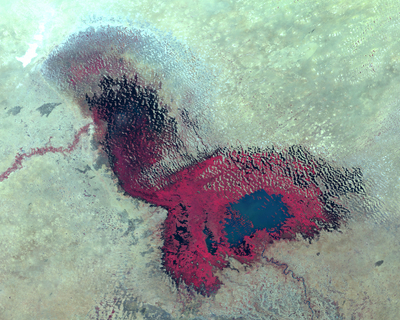
False colour combination (channels 13,4,2)
In order to help you differentiate adjacent image features, in particular water and vegetation (i.e. reed), try different false colour combinations. Assign RGB values to other channels instead of natural red, green, and blue. False colour combinations that are very commonly used for MERIS imagery are:
| R | = channel 13 | R | = channel 13 | | G | = channel 5 | G | = channel 4 | | B | = channel 1 | B | = channel 2 |
|
Interactive Stretching and Histogram Equalisation can help differentiate between features.
After trying different colour combinations, select the one you think is best for differentiating different image features. Write a description of this image. Make a note of the difficulties you encountered in delineating the lake.
| |
| | The shrinking of Lake Chad IntroductionBackgroundExercises Exercise 2: The shrinking of Lake ChadExercise 3: The importance of water in the Lake Chad areaEduspace - Software LEOWorks 4 (MacOS)LEOWorks 4 (Linux)LEOWorks 4 (Windows)Eduspace - Download Landsat MSS_January 1973.tifLandsat TM_December 1986.tifEnvisat MERIS_January 2011.tif
|