A year on from the Asian tsunami, satellites are aiding regional rebuilding
The deadly Indian Ocean tsunami that swept across coastlines on 26 December 2004 took the lives of more than 200 000 people. The sheer scale of the catastrophe meant that Earth Observation was vital both for damage assessment and for co-ordinating emergency activities. Through the year that followed, satellite-based maps from ESA's Respond consortium continued to support rebuilding efforts.
Space-based assistance is being provided through Global Monitoring for Environment and Security initiative (GMES). This flagship initiative of ESA and the European Union aims to combine Earth- and space-based data sources and develop an integrated environmental monitoring capability to benefit European and world citizens. ESA is developing GMES pilot services in close conjunction with a large community of operational users.
A segment of GMES Services known as Respond is addressing geo-spatial information requirements of the humanitarian aid community. This ESA-sponsored alliance of European and international organisations works with industry and the humanitarian aid community to improve access to maps, satellite images and geo-information. Respond was founded in 2003, though the Asian tsunami represents the largest-scale event dealt with so far.
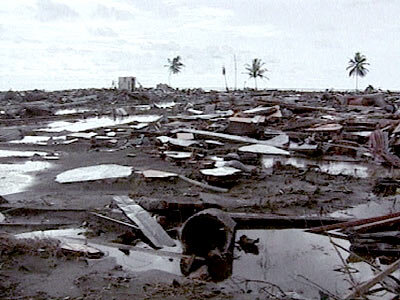
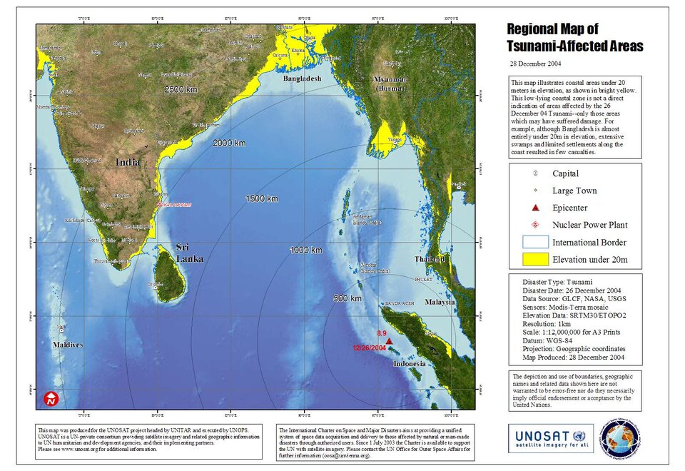
The undersea earthquake off the coast of the Indonesian island of Sumatra that triggered the tsunami was the second-largest in recorded history, with billions of tonnes of seawater sent into motion by uplift of the ocean floor. Within a half-hour of the quake the first wave hit Sumatra, with the coastal city of Banda Aceh almost destroyed. From there, the tsunami carried on to strike nations across the rim of the Indian Ocean as far distant as the Maldives and Somalia.
Immediately following the disaster, the International Charter on Space and Major Disasters was activated, prioritising the acquisition of satellite data over the affected region.
Three Charter activations were triggered on the 26th of December 2004, one by the United Nations Office of Outer Space Affairs (UNOOSA) for Indonesia and Thailand, one by the French Civil Protection for Sri Lanka and another by the Indian Space Research Organisation (ISRO) for India, the Maldives, Andaman and Nicobar Islands. These were grouped together under ISRO's overall management with a considerable imagery data base being organised by the Charter's member space agencies.
In response to this, many Respond partners started work on their individual initiative then later with the support of ESA. Respond provided as many resources as possible during the relief phase and also in the recovery, rehabilitation and reconstruction phases.
Damage mapping products maps were provided by Respond partners including the Rapid Disaster Mapping Service of the SERTIT company based in France, the Center for Satellite Based Crisis Information (ZKI) of the German Aerospace Center (DLR), provider of satellite maps and images to United Nations agencies UNOSAT, the Joint Research Centre of the European Commission (EC-JRC), Infoterra UK, Belgium-based company Keyobs and Sweden-based Metria. This effort began from day one and has continued throughout the 2005 calendar year.

The Respond alliance carried out a large amount of rapid mapping in the immediate days to follow creating over 210 individual maps involving more than 19 different satellites answering to the needs of relief organisation and fulfilling the Charter requirements as swiftly as possible.
All products were made freely available over the web sites of the Respond partners, which were distributed widely and reached hundreds and some time even over thousand downloads a day. In January 2005 alone UNOSAT recorded more than 350,000 downloads of maps produced by DLR, JRC, Infoterra UK and UNOSAT itself.
SERTIT started producing maps on 29 December 2004 over Sri Lanka at the request of the French Space Agency CNES and carried out a large amount of rapid mapping in the following days. Initially SERTIT produced potentially affected zone maps, based on terrain height above sea level. Event location space-maps were then produced within eight hours of receiving Very High Resolution (VHR) data. SERTIT’s Rapid Mapping Service produced over 90 products for affected areas in Sri Lanka and Sumatra - Banda Aceh, Lho Nga and Meulaboh - alongside the Respond consortium. These products included event extent, event intensity and impact mapping.
This short-term crisis and damage mapping was not the end of the story, however. Respond members have gone on producing more maps since then, in response to longer-term needs of the humanitarian aid sector and ongoing rebuilding efforts of the communities and countries involved.
ZKI of DLR for example has provided dozens of maps to various relief organisations including German Red Cross (DRK), Médecins Sans Frontières (MSF) and the German Technical Relief agency (THW). DRK has continued to use satellite derived pre- and post-tsunami maps extensively to supervise, direct and manage its reconstruction operations in the Calang area of Sumatra.
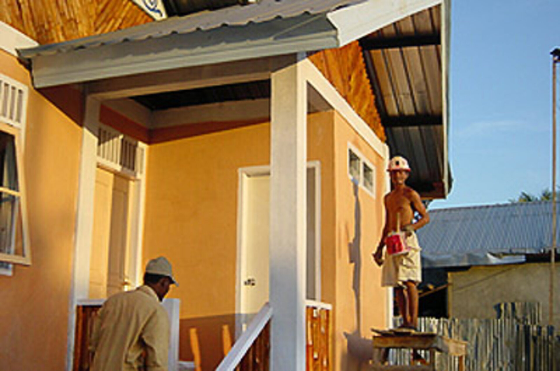
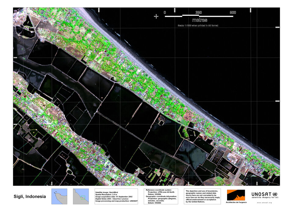
Meanwhile the town of Sigli in the east of Sumatra's Aceh province, home to 13 965 people, was two-thirds destroyed in the tsunami. Today more than 180 new homes are under construction (out of a planned 536), along with a new school and a repaired road. More than 40 small and motorised fishing boats have been built, along with 12 larger trawlers repaired and re-launched, at the same time as damaged harbour infrastructure has been reconstructed.
The work has been undertaken by French non-governmental organisation (NGO) Emergency Architects (Architects de l'Urgence or ADU), in cooperation with local architects and students of architecture. ADU is similarly active in the town of Muthur in the Trincomalee region of Sri Lanka, which was a fishing village left devastated in the tsunami's aftermath. Now some 45 homes out of a planned 120 are under development, with a small trade store centre, community centre, place of workshop and fish stock stores being constructed.

The objective of ADU in both locations is to return economic opportunity to local people, repair schools for childrens' education, and re-house disaster victims, carried out with sensitivity to local conditions and a strategy of mitigating further natural risks. In both cases, their intervention has been guided by satellite imagery, with Respond partner UNOSAT - provider of satellite data for UN agencies - delivering ADU detailed before-and-after damage maps of affected areas.
UNOSAT has developed a 'Tsunami Imagery Bank' hosting more than 650 high- and medium-resolution Earth Observation images acquired before and after the disaster, which are available for humanitarian uses. Over both Sigli and Muthur UNOSAT has processed optical satellite maps being utilised by ADU in order to design their master plan, around which the reconstruction effort is based.
"It is important to have this sort of images to make a first evaluation before going into the field," explained Alice Moreira of ADU. "To have these images of before and after the disaster allowed us to make a rapid evaluation of local situations, and of the damage done. We can consider in a more effective way how best to intervene."

Working on a larger scale, Respond partners working together have also delivered damage maps intended to assess the amount of debris left by waves for towns and village within Aceh province. Tremendous amounts of debris presented an added burden on reconstruction which needed to be quantified before its removal could be planned.
In March Respond was requested by the United Nations Development Programme (UNDP) and the UN's Humanitarian Information Centre (HIC) in Banda Aceh to provide debris maps for eight towns and villages within Aceh province. The desired estimate was rapidly provided by the Respond team with thematic analysis performed by DLR ZKI.
Very-high resolution imagery, resolving image details smaller than one metre, was utilised on a before-and-after basis, with interpreters looking for built-up areas which were now covered with debris, including streets, gardens, parks and small agricultural farming areas. Banda Aceh turned out to be by far the most badly affected settlement, with approximately 2641 hectares covered.
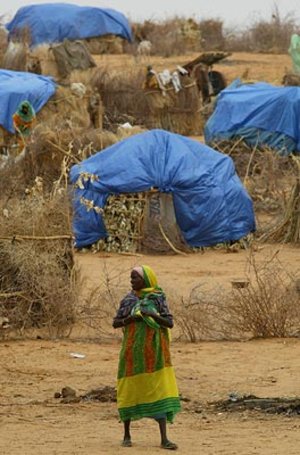
Similar satellite images were utilised for a different purpose in the Maldives. In July Respond partner Keyobs produced satellite maps of damaged sections of Guraidhoo and Kulhudhuffushi islands in the Maldives, which is an atoll of more than 200 inhabited islands. The islands stand only a few metres above sea level, so the tsunami waves washed right over them, contaminating freshwater supplies with salt water and damaging sanitation systems.
The maps for these two islands were validated by fellow partner and Respond coordinator, Infoterra UK, for delivery to the Asian Development Bank. The Bank utilised the maps to help design water supply, sanitation and solid waste projects – including selecting the location of sewage treatment plants and solid waste management centres, as well as determining the length of sewers and potential sea-outfall systems.
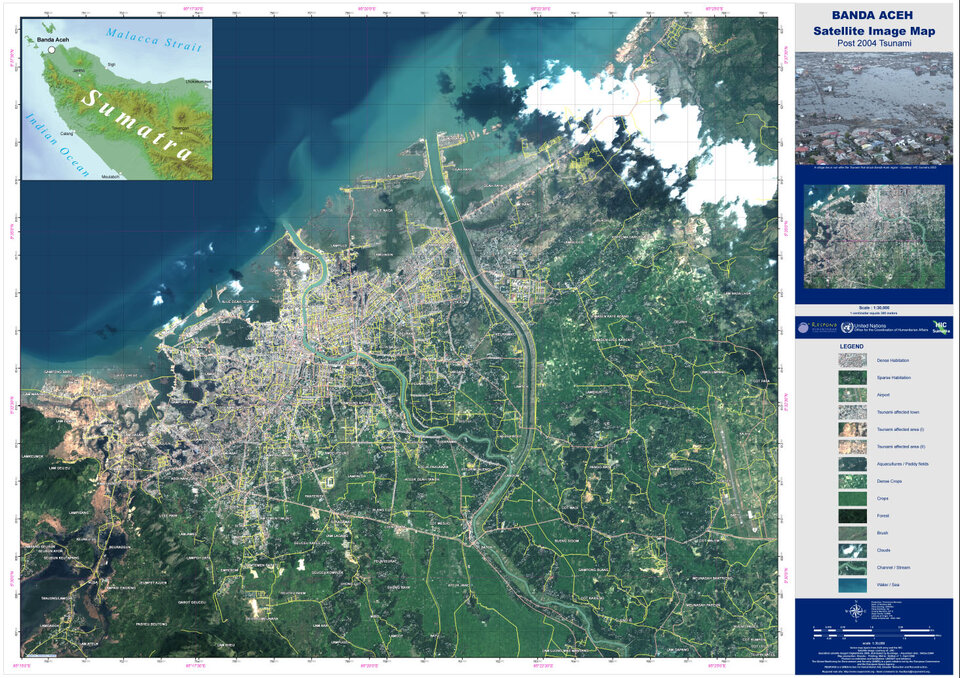
A year on in Sumatra's Banda Aceh, rubble and mud has been cleared from the city streets and rebuilding proceeds. Many Respond products have been produced of this area, but one in particular – a detailed street map of the post-tsunami settlement, based on high-resolution satellite data – is proving especially useful in guiding reconstruction efforts.

The Banda Aceh city map represents a team Respond effort – it was designed by Keyobs and printed by Metria, with input from the Banda Aceh UN HIC arranged through UNOSAT. Other Respond partners played a role in its thorough review process.
As well as being made available in electronic form, a thousand waterproofed-paper copies of the map were delivered to the UN HIC for local use. The maps have been distributed to more than 400 groups operating in Banda Aceh. HIC staff report the map is being utilised in a variety of ways including for "town planning, security, transport planning, boundary checks especially where it follows natural features, change analysis for the town before and after the tsunami and internal displaced person (IDP) movement and shelter location."
The fact that the HIC was able to have input into the map design and scale, and take account of local needs, is one reason for the map's popularity. Some copies have even gone astray from their official owners, and ended up for sale at high prices in local markets.
Furthermore as part of its support to the Group on Earth Observations (GEO) Tsunami Working Group, UNOSAT is actively promoting and facilitating the use of the satellite imagery and value added products in the on-going development of the Tsunami Early Warning System coordinated by the Intergovernmental Oceanographic Commission of UNESCO, the United Nations Economic, Social and Cultural Organisation.
About the International Charter

The International Charter on Space and Major Disasters is a joint effort by space agencies worldwide to put space technology at the service of rescue authorities in the event of a major disaster. Each member agency has demonstrated its commitment to using space technology to serve humankind when it is most in need of assistance—when disasters of both natural and human origin strike the world’s communities or wreak havoc on the environment.
Following the UNISPACE III conference held in Vienna, Austria in July 1999, the European and French space agencies (ESA and CNES) initiated the Charter with the Canadian Space Agency (CSA) signing it on 20 October 2000.
Other members include the Indian Space Research Organisation (ISRO), the US National Oceanic and Atmospheric Administration (NOAA), the Argentine Space Agency (CONAE) and the Japan Aerospace Exploitation Agency (JAXA).
About Respond
Respond is an alliance of European and international organisations with industry working with the humanitarian aid community to improve access to maps, satellite images and geo-information.
Respond has been set up as part of GMES Services, an ESA-sponsored portfolio of pilot services undertaken as part of the Global Monitoring for Environment and Security (GMES) initiative. This joint effort between ESA and the European Union aims to build a global monitoring capability in support of Europe's environmental and sustainable development goals. Initial GMES Services are already operational, addressing a range of sectors from atmospheric chemistry monitoring to geological hazard assessment.