Envisat's rainbow vision detects ground moving at pace fingernails grow
Originally developed to pinpoint attacking aircraft during World War Two, today's advanced radar technology can detect a very different moving target: shifts of the Earth's crust that occur as slowly as the growth of your fingernails.
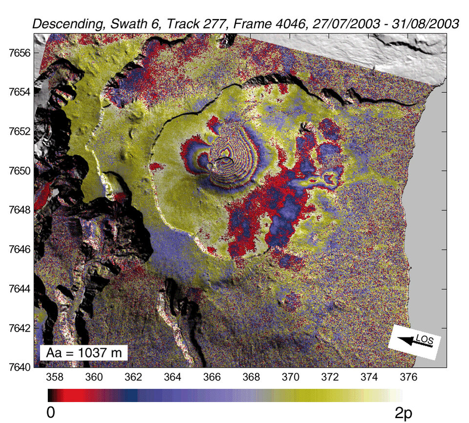
Radar data from satellites such as ESA's Envisat are used to construct 'interferograms' that show millimetre-scale land movements. These rainbow-hued images provide scientists with new insights into tectonic motion, and an enhanced ability to calculate hazards arising when this slow motion speeds up, in the form of earthquakes or volcanic activity.
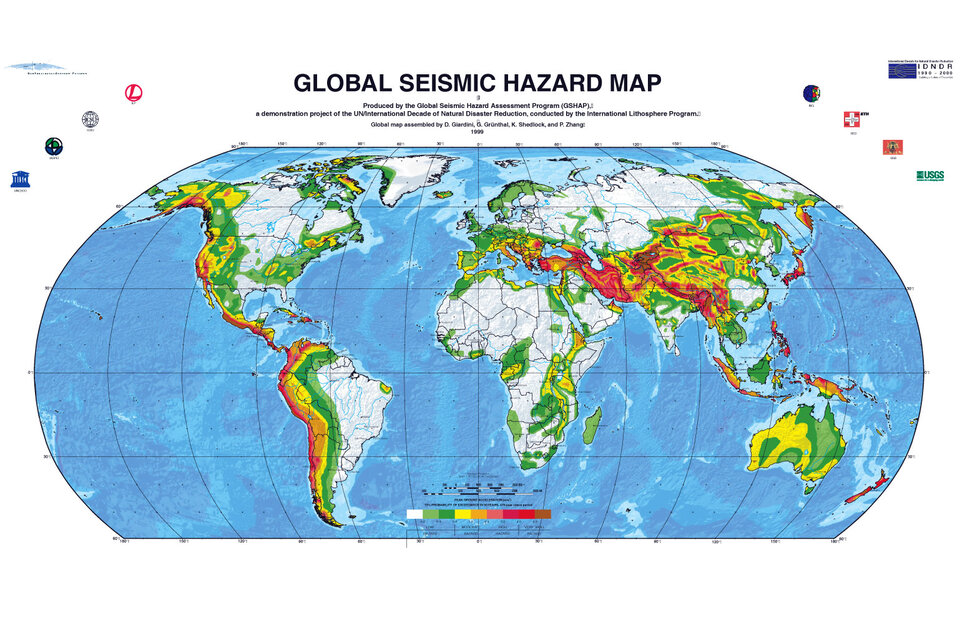
The ten-instrument payload on Envisat includes an Advanced Synthetic Aperture Radar (ASAR) instrument designed to acquire radar images of the Earth's surface. Part of Envisat's assigned 'background mission' as it orbits the world every 100 minutes is to prioritise ASAR acquisitions over the seismic belts that cover 15% of the land surface.
"By the time Envisat completes its nominal five-year mission we should have a satisfactory amount of images across all the seismic belts," said Professor Barry Parsons of the Centre for the Observation and Modelling of Earthquakes and Tectonics at Oxford University.
"To detect the fine ground deformation we are interested in, we require repeated radar images of each site. We then combine pairs of images together using a technique called SAR interferometry, or InSAR for short, to show up any change between acquisitions." (For more information see link: How does interferometry work?)
To accurately measure the slow build up of strain as tectonic plates move against each other along Earth's seismic belts, multiple interferograms are combined, requiring many individual SAR images.
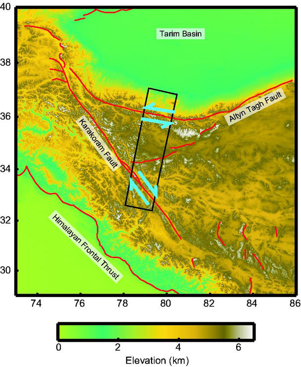
"The reason for this is to minimise any atmospheric interference, relative to the small crustal deformation signal we are interested in," added Parsons. "Using data from Envisat's predecessor ERS, our group has recently measured tectonic movement across western Tibet with an accuracy of a few millimetres per year. The results show that slip rates across the major faults in the region are much smaller than had been previously thought and that the Tibetan plateau deforms like a fluid."
InSAR can also be used to analyse much more abrupt ground motion: researchers have recently been employing Envisat data to chart ground deformation associated with the extremely active Piton de la Fournaise volcano on Réunion Island in the Indian Ocean, and to identify the fault that caused Iran's Bam earthquake in December 2003.
Finding fault after the Bam disaster
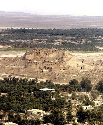
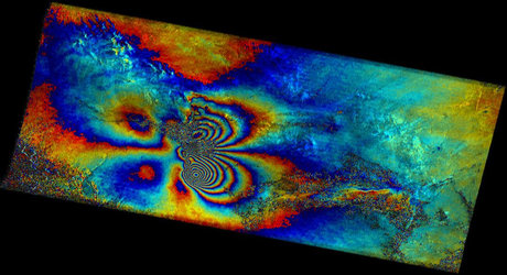
More than 26000 people were killed on 26 December 2003, when a 6.3 Richter scale earthquake devastated the Iranian oasis town of Bam. Its ancient citadel – designated a World Heritage site – collapsed into rubble. The Charter on Space and Major Disasters was activated so that spacecraft including Envisat acquired imagery to support international relief efforts.
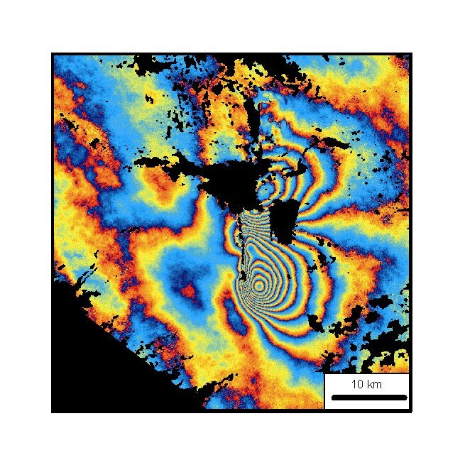
Following Envisat's background mission, a pre-earthquake image had been acquired of the Bam vicinity on 3 December 2003, and this was combined with a post-quake image acquired 7 January 2004 – the earliest re-acquisition date possible due to Envisat's 35-day global coverage – to perform InSAR.
"This is the first time that Envisat data has been used to produce an interferogram following a major earthquake," said Parsons, part of an international team studying the Bam quake including participants from the Geological Survey of Iran and the US Jet Propulsion Laboratory.
The results were surprising, establishing that while Bam lies in a seismic belt, this particular quake had come from a point no one had expected. Iran is like the filling in a geological sandwich as the Arabian plate advances into Eurasia, and so many seismic faults occur within its territory. Most notably, the Gowk fault located west of Bam has had several large quakes take place on it during the last two decades.
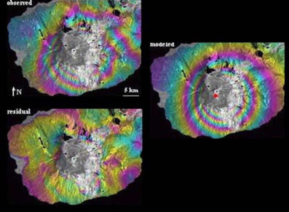
However the Envisat interferogram showed the Bam quake had resulted from the rupture of a previously undetected fault that extends under the southern part of town, its existence missed by ground surveys. The fault showed up as a distinct band of discontinuity in the interferogram, with motion either side of it ranging from around five up to as high as 30 centimetres.
As well as highlighting such surface changes, InSAR results can be used to indirectly peer beneath the ground, with software models calculating what geological occurrences fit the surface events. With Bam they found a slip exceeding two metres had taken place at a mean depth of 5.5 kilometres, along a distinct type of fault.
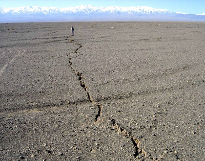
The fault is what is called a blind 'slip-strike' fault, where blocks of crust move sideways against each other, producing only small surface effects – with the word 'blind' meaning the rupture does not extend all the way to the surface," Parsons explained. "Despite this term, blind faults typically produce tell-tale signs in the surface landscape, but in this case all clues have been hidden by later floods and sediment deposits."
The discovery of this fault from space fleshes out the scientific understanding of geological processes in this volatile region, and makes more accurate hazard mapping possible in future. The team responsible published their preliminary work in Geophysical Research Letters Volume 31, and analysis of further Envisat InSAR results is ongoing.
Coming around again
The more precisely a spacecraft's position can be controlled, the smaller the InSAR image baseline - the spatial distance between initial and follow-up image acquisitions - and the better the quality of the final interferogram. During Envisat's initial Bam revisit the baseline was large enough that ERS digital elevation data was needed to subtract topographic effects caused by a shifted view angle.
However for its subsequent revisit, 35 days later, the steering of the spacecraft was so precise that no topographic compensation was required, representing a formidable operational achievement for Envisat.
"Our Flight Dynamics team have computed an accuracy of 93 cm using precise orbit determination results from DORIS (Doppler Orbitography and Radiopositioning Integrated by Satellite) and laser ranging observations," stated Envisat Spacecraft Manager Andreas Rudolph.
"Special orbit manoeuvres were required to achieve this accuracy, along with hard work from teams at the European Space Operations Centre (ESOC) here in Germany and the European Space Research Institute (ESRIN) in Italy – not to mention a bit of luck!"
Surveying an active volcano
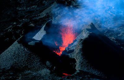
Radar interferometry is used to study earthquakes as well as volcanoes - Envisat has been gathering data on one extremely lively example of the latter.
Standing 2631 metres above the Indian Ocean, the Piton de la Fournaise volcano is not situated along seismic belts or the associated 'Ring of Fire' but – like Hawaii on the other side of the planet – it is sited above a magma 'hotspot' in the Earth's mantle.
The Institut de Physique du Globe de Paris (IPGP) operates an in-situ Volcano Observatory to monitor eruptions and associated activity.
"We have been observing this basaltic volcano for the last 25 years – it is one of the most active volcanoes in the world," commented Pierre Briole of IPGP. "In the last six years there have been 13 eruptions, with an average duration of one month. Between 1992 and 1998 was a quiet time, while eight eruptions occurred between 1984 and 1992."
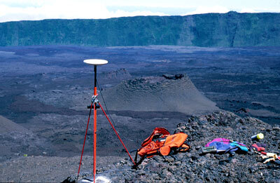
Deep subterranean processes drive surface volcanic activity – lava fissures and eruptions occur because of lava channels or 'dikes' that extend up from high pressure magma chambers. Ground deformation either up or down in the vicinity of a volcano provides insights into what is taking place underground, but until recently the amount of ground points that could be measured was very limited.
"Back in the time of ground-based geodetic instruments it took several weeks to measure the coordinates of perhaps 20 points, to an accuracy of about one centimetre," remembered Briole. "Then in the early 1990s came the Global Positioning System (GPS). Using GPS we could increase the number of points measured tenfold during a weeklong campaign, down to half-centimetre accuracy. But the ground deformation caused by an eruption is typically extremely localised in space, and these 200 points are spread out across the volcano's area."
It took another space-based technology to improve on GPS: interferograms of Piton de la Fournaise, based on more than 60 Envisat images acquired during the last year. IPGP is part of a team making use of the data that also includes participants from Blaise Pascal (Clermont-Ferrand II) and Réunion Universities.
"We are lucky with Piton de la Fournaise, because its remote location in the middle of the ocean means there are no clashes with other potential Envisat targets, and so we get more acquisitions than most of the other users of ASAR imagery," Briole added. "InSAR from Envisat has proved an extremely powerful tool for us, because it provides a very high density of information across the entire volcano.
"With new eruptions taking place so often our ground campaigns could not keep pace but interferometry gives us data on each eruption. And while the volcano is very difficult place to operate in – often with poor visibility from the weather and a very steep eastern flank – all parts of the volcano down to vegetation line are accessible with InSAR."
InSAR reveals a pattern of ground inflation in the months preceding a new eruption, as pressure in the magma chamber increases. Following an eruption the pressure abates and deflation occurs.
Also revealed are localised deformations that occur as magma dikes propagate and reach the surface. The extent of the deformation associated with a new fissure indicates the depth at which it originates – the wider the inflation, the deeper down the dike has come from.
InSAR volcanic monitoring was first established using ERS data, producing interferograms showing Italy's highly-active Mount Etna appearing to 'breathe' between eruptions. And interferogram surveys of apparently extinct volcanoes along remote parts of the Andes have shown ground motion indicating some are in fact still active.
"There are plenty of interesting lines of enquiry using this technique, including the question of whether it is possible to predict when a volcano is going to erupt, and - with seismic faults often occurring near volcanoes - the question of whether seismic activity and volcanic eruptions are linked," Briole added.
"For now our team are interested in characterising Piton de la Fournaise as accurately as we can, to perfect techniques we can later apply to volcanoes elsewhere and if possible to increase the number of acquisitions so as to demonstrate that InSAR monitoring of volcanoes has operational potential, providing early warning for civil protection authorities."