Arctic sea ice annual freeze-up underway
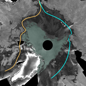
After reaching the second-lowest extent ever recorded last month, sea ice in the Arctic has begun to refreeze in the face of autumn temperatures, closing both the Northern Sea Route and the direct route through the Northwest Passage.
This year marked the first time since satellite measurements began in the 1970s that the Northern Sea Route, also known as the Northeast Passage, and the Northwest Passage were both open at the same time for a few weeks.
"NIC analysis of ESA’s Envisat and other satellite datasets indicated that the Northern Sea Route opened when a path through the Vilkitski Strait finally cleared by 5 September," NIC Chief Scientist Dr Pablo Clemente-Colón said via email from aboard the US Coast Guard icebreaker Healy in the Arctic, where he is conducting joint mapping operations with the Canadian Coast Guard.
"This is the first time in our charting records that both historic passages opened up in the same year," Clemente-Colón said. "Both of the routes appeared as closed by 22 September."

The Northwest Passage’s most direct route, a long-sought shortcut from Europe to Asia through the Canadian Arctic that has been historically impassable, opened up for the second consecutive time this year.
"As early as 18 August 2008 the Northwest Passage began appearing navigable in the US National Ice Center (NIC) analysis of Envisat Advanced Synthetic Aperture Radar (ASAR) data although we were cautious in announcing it as a significant amount of ice was still prevalent," Clemente-Colón said.
The indirect, more southerly route – called the Amundsen Northwest Passage – opened up in July 2008, and according to ASAR images is about to close in the coming days.
The Northern Sea Route extends from the Norwegian Sea, along the Arctic coast of Asia and through the Bering Sea to the Pacific Ocean, while the Northwest Passage runs along the north coast of the North American continent.
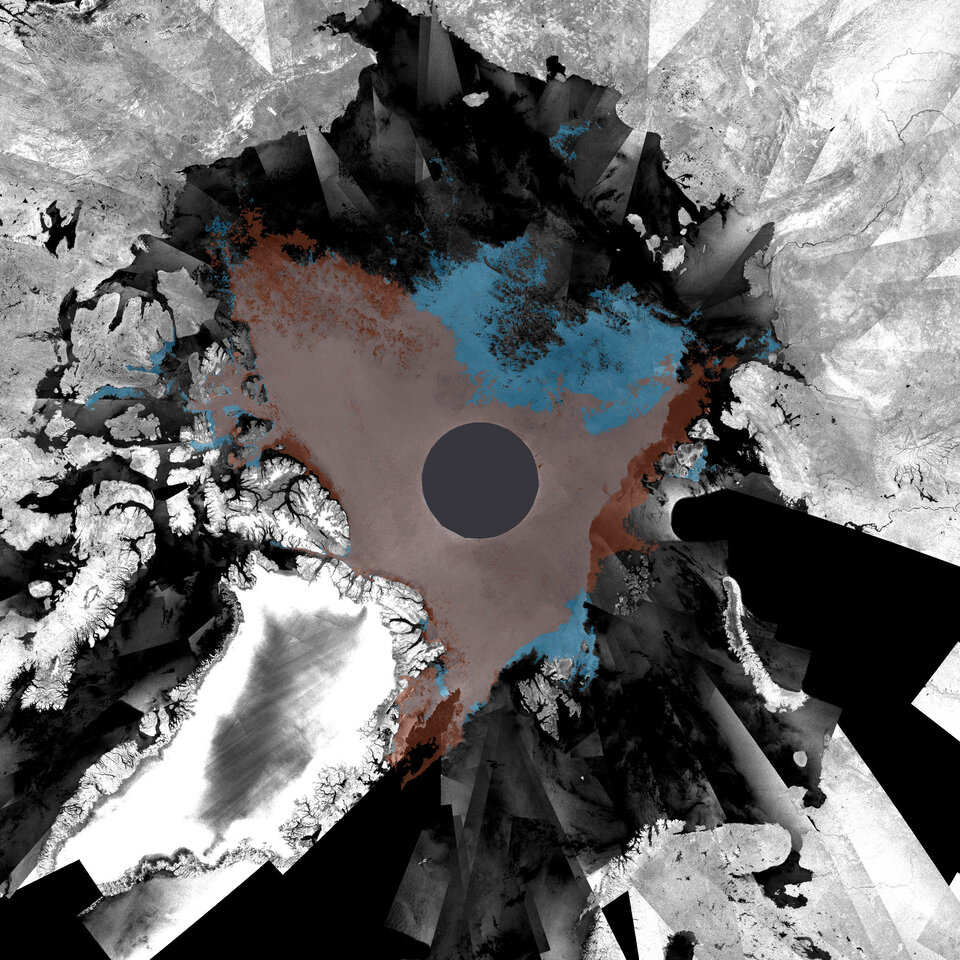
Each year, the Arctic Ocean experiences the formation and then melting of vast amounts of ice that floats on the sea surface, but the rate of overall loss has accelerated.
During the last 30 years, satellites that have been observing the Arctic have witnessed reductions in the minimum ice extent at the end of summer from around 8 million km² in the early 1980s to the historic minimum of less than 4.24 million km² in 2007, as observed by Envisat.
The fact that this year’s minimum extent, which was well below the long-term average, did not break last year’s record does not signify a recovery.
"Although last year’s summer sea ice minimum extent record was not broken, a record amount of the thickest multiyear sea ice was actually lost this season impacting the thickness of the sea ice presently found around the North Pole region and setting the stage for more minimum or near-minimum records in upcoming years," Clemente-Colón said.

The Arctic is one of the most inaccessible regions on Earth and is prone to long periods of bad weather and extended darkness, so obtaining measurements of sea ice was difficult before the advent of satellites.
Radar instruments aboard Earth observation satellites, such as Envisat’s ASAR sensor, are particularly suited for monitoring Polar Regions because they are able to acquire images through clouds and darkness.
ESA has been providing satellite data on the cryosphere for more than 20 years. The agency is currently contributing to the International Polar Year 2007-2008, one of the most ambitious coordinated science programmes ever undertaken in the Arctic and Antarctic.

Further exploitation of data collected over the Arctic since 1991 is part of an ESA Initiative on Climate Change that will be proposed to the ESA Member States at its Ministerial Conference in November 2008. The proposal aims to ensure delivery of appropriate information on climate variables derived from satellites.
In 2009, ESA will make another significant contribution research into the cryosphere with the launch of CryoSat-2. The observations made over the three-year lifetime of the mission will provide conclusive evidence on the rates at which ice thickness and cover is diminishing.