ESA makes first GOCE dataset available
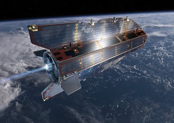
The first products based on GOCE satellite data are now available online through ESA’s Earth observation user services tools. ESA launched the satellite in March 2009 on a mission to map Earth's gravity with unprecedented accuracy and spatial resolution.
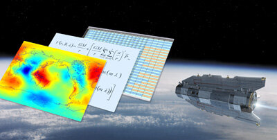
The final gravity map and model of the geoid based on GOCE data will provide users with well-defined products that will be instrumental in advancing science and applications in a broad range of disciplines.
However, there are a number of steps that have to be taken in order to turn the raw data into suitable products for users.
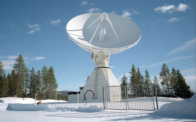
Raw data are downlinked from GOCE to the ground stations in Kiruna, northern Sweden, and on Svalbard, Norway. They are immediately forwarded to the Flight Operations Segment at ESA's European Space Operations Centre (ESOC) in Darmstadt, Germany, which then links them through to the Payload Data Ground Segment at ESA's European Space Research Institute (ESRIN) in Frascati, Italy. Here, through a process of calibration and validation, the data undergo an important transformation from telemetry to 'level-1b' data products.
Level-1b products are the time series of converted, calibrated and validated measurements taken by GOCE. They consist mainly of the gravity gradients in the instrument reference system and the orbit data (satellite-to-satellite tracking observations, positions and velocity) in an Earth-fixed coordinate system.

In addition, satellite data such as the attitude of the spacecraft and other housekeeping data complete the level-1b data.
These level-1b data, covering the period 1–30 November 2009, are available free of charge to scientific and non-commercial users, and much more will come in the following weeks and months.
"After an intensive calibration and validation phase, we are all very happy to see the science community at large getting involved in the exploitation of the data," ESA GOCE Mission Manager Rune Floberghagen said.
"GOCE is proving to be a remarkable Earth science mission and we are more than confident that these data will not only change the way we see the gravity field of our planet but also the way the gravity field information is used in many branches of the geosciences."
Subsequently, these level-1b data will be processed to level-2 through the High-level Processing Facility (HPF). Under ESA's control, 10 European universities and research facilities that have complementary expertise in gravity and geodesy-related science fields, have joined together and will be operating the HPF throughout GOCE’s lifetime.
The first gravity field model (level-2 data) will be released at ESA's Living Planet Symposium in Bergen, Norway, from 28 June to 2 July.
"The Living Planet Symposium will in many ways be a coming-out event for GOCE. We will spend two full days on the findings of the mission so far, and we certainly expect the release of our first gravity model to mark the beginning of a long and successful series of gravity field models based on GOCE’s novel measurement techniques," Floberghagen said.
The final gravity map and model of the geoid will provide users with well-defined data products that will be instrumental in advancing science and applications in a broad range of disciplines, ranging from geodesy, geophysics and surveying to oceanography and sea-level research.
For general opportunities to obtain Earth observation data, please visit ESA's Earth Observation Principal Investigator Portal or the GOCE technical website.