Last 'tango' in space
Adding to their unique information from previous tandem missions, ESA’s ERS-2 and Envisat satellites have been paired up again – for the last time. Data from this final duet are generating 3D models of glaciers and low-lying coastal areas.
The 2010 tandem campaign continues the work of the satellites’ earlier joint efforts on measuring the speed of fast-moving glaciers, detecting land-ice motion and developing elevation models over flat terrain.
Their third pairing took place from February to April 2010 with both satellites acquiring radar data for the first time over Antarctica’s coastal glaciers and ice shelves just 30 minutes apart.
By combining their synthetic aperture radar (SAR) tandem data, acquired over the same area within a short time, changes that occurred quickly can be detected. Some fast-moving glaciers, for instance, move more than 200 m per year and can move as much as 1 cm in 30 minutes.
This technique, known as SAR interferometry, or InSAR, has proven to be very useful for monitoring glaciers, detecting surface deformation and creating digital elevation models (DEMs).
Dr Paolo Pasquali, Technical Director of Switzerland’s Sarmap, is using the SAR data to document the fast dynamic of sea ice and icebergs as they move and detach from the Larsen Ice Shelf.

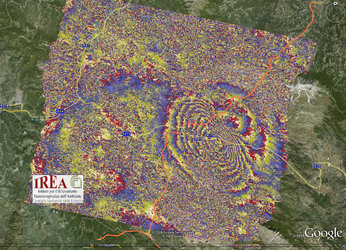
In the image (right), acquired on 26 February over the Antarctica Peninsula, the brightness of the pixels depends on the reflectivity of the terrain to the radar, while the colour variation relates to the velocity of motion of the sea ice/icebergs and to its direction.
Denser fringes (colour variations) represent faster displacements. One full colour cycle (e.g. from red to red) corresponds to around 1.4 cm/hour of additional displacement.
"These measures are of great interest for monitoring the fast dynamic of sea ice and for identifying the ground ice line," Dr Pasquali said. "We have also plenty of other very nice sea ice examples obtained during the first and second tandem campaigns over the Northern Canada-Alaska region."
A fourth campaign, from July to October 2010, focused on low-lying coastal areas, such as New Orleans in USA and the Po River Mouth in Italy. This information will be used for various applications in many different fields, in particular for creating accurate DEMs of coastal areas that could be used to help manage floods.
Dr Urs Wegmuller, President of GAMMA Remote Sensing, is using the data to generate valuable information about the topography and state of permafrost areas. The image below characterises the land cover in the Nenets Autonomous Okrug region in Arctic Northwest Russia.

"In flat parts, the surface topography can be retrieved in great detail, which is important for understanding the hydrology of this permafrost area," Dr Wegmuller said.
Realising the tandem campaign was a team effort. ERS-2’s instruments operate only within range of a ground station because its tape recorder broke in 2003, the 2010 Tandem Campaign Manager Siegfried Schmuck explained.
"To help ESA get data from over areas where it didn’t have an available station, NASA and the German Aerospace Center offered up their Antarctic antenna stations for ERS-2 data downlinks. It was a really great experience to see how well the teams from different continents worked together, and we are glad the data are being put to good use."
Other ground stations within the ERS-2 network, such as the Khanty-Mansiysk station in Siberia, contributed to the success of the campaigns.
As planned, the fourth campaign ended on 22 October, the day in which Envisat was placed into a new orbit (from about 800 km to about 783 km) to minimise fuel usage and extend its life by three years. As a consequence, Envisat and ERS-2 are now in two different orbits and can no longer acquire tandem SAR data.
ESA will make the datasets from this final joint flight available to everyone as soon as they are processed and validated.