Greek ferry voyage to test EGNOS, Europe’s new satellite navigation system
On Friday 16 March, a ferry will set sail from the port of Piraeus, bound for the Greek island of Santorini with some special passengers and navigation equipment on board.
The equipment consists of a receiver to pick up the signal broadcast by Europe's fledgling EGNOS satellite navigation system and the passengers include officials from the Greek Navy, Greek shipping, national telecommunications agencies, the European Commission and the European Space Agency.
The purpose of the voyage is to demonstrate how the accuracy and eventual integrity of the EGNOS signal could improve navigation in the difficult Greek archipelago. EGNOS should make it possible to navigate accurately within the confined channels and to identify harbour entrances to within a few metres without other navigation aids.
The demonstration is one of several events illustrating how EGNOS is developing as a new navigation service. During early 2000, the system was used to guide a large ship to its berth in the harbour at Genoa, Italy. On another occasion, last November, a Fiat car, driven around a track in Turin, Italy, showed that EGNOS has the potential to determine position to within a metre. Several flight demonstrations have also shown that the improved accuracy and integrity of the EGNOS signal could lead to much more effective use of airspace.
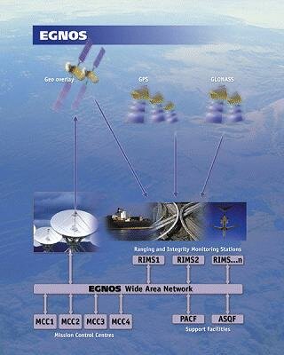
EGNOS, which stands for European Geostationary Navigation Overlay Service, is being developed by ESA in conjunction with the European Commission and Eurocontrol, the European Organisation for Safety of Air Navigation. It improves the accuracy and reliability of navigation signals from the military-controlled US GPS and Russian GLONASS global satellite navigation systems to the point where they can be used for safety critical applications, such as flying aircraft and navigating ships through narrow channels. It is due to become operational in early 2004.
EGNOS receives signals from the GPS and GLONASS satellites and, using specialised hardware, adds a correction factor which makes them accurate to five metres or better. The signals are then beamed back into space, and broadcast by the EGNOS transponders onboard Inmarsat satellites and picked up by receiving equipment, fitted into vehicles. When EGNOS is fully operational, it will have three satellites.
This week's test in Greece will be the first since additional ranging stations became available in the Mediterranean area, thanks to a co-operation with the Italian tests bed developments. It will monitor the improvement brought about by the extra ranging stations and also test the system near the edge of its geographical area of operation.
EGNOS shows not only greater accuracy but also greater consistency and reliability than GPS alone. The fully operational system will be capable of alerting users within less than six seconds of a malfunction of the GPS or GLONASS satellite constellations.
EGNOS is a first step towards Galileo, a fully-comprehensive European global satellite navigation system. Consisting of 30 satellites in medium Earth orbit, Galileo will be under civilian control and will provide a reliable, accurate and guaranteed satellite navigation service from 2006/8 onwards.