Measuring soil from the sky for ROSE-L and CHIME
Gathering datasets about our soil, from the ground, the air and from space, is part of the robust preparation for these two new European satellites set to extend the capabilities of the Copernicus family of Sentinel missions.
Flying above Bavaria, scientists have been busy this summer testing the ‘eyes’ of two of Europe’s future satellite missions. Their goal: to help prepare for the upcoming Copernicus Sentinel satellites – ROSE-L and CHIME. By collecting a wealth of data on soil and vegetation across different wavelengths from the air and on the ground, the team has built a unique dataset that will not only help guide the missions’ further development but also support crucial validation once the satellites are in orbit.

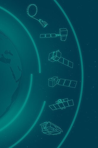
Copernicus Sentinel Expansion missions
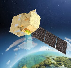
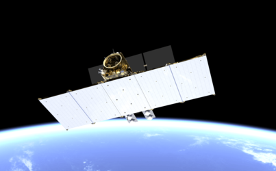
ROSE-L – short for Radar Observing System for Europe at L-band – and CHIME – the Copernicus Hyperspectral Imaging Mission for the Environment – are two of the six new Copernicus Sentinel Expansion missions.
Developed by ESA, the new Copernicus Sentinel Expansion missions will address emerging EU policy needs, close information gaps for users, and extend the capabilities of the current fleet of Copernicus missions.
Equipped with a powerful L-band synthetic aperture radar, ROSE-L will observe Earth’s land, oceans and ice, day and night and in all weather. It will deliver frequent, high-resolution images and provide information that isn’t available from today’s satellites, including key insights into forests and land cover. This will help track the terrestrial carbon cycle and improve carbon accounting.
Meanwhile, CHIME will carry a new imaging spectrometer, delivering systematic, high-resolution hyperspectral images. These will improve the way we monitor agriculture and manage natural resources by revealing details about crop health and soil quality. CHIME will also support forest management, monitor inland and coastal waters, and even detect minerals on Earth’s surface.
Field campaigns in Bavaria
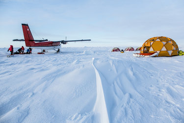
As part of their development, scientists gathered in Bavaria, southeast Germany, for two field campaigns to test instruments for the upcoming missions. From March to July 2025, teams from several institutes worked together to build a comprehensive agricultural dataset. By combining fieldwork, airborne surveys and satellite observations, the campaigns synchronised multiple platforms and sensors to track soil and vegetation across different scales.
One part of the campaign focused on a high-performance airborne radar system, F-SAR, from the German Aerospace Centre’s Microwaves and Radar Institute. During the campaign, researchers conducted 23 precision flights over the test area, scheduled every six days to match the observation cycle ROSE-L will follow once in orbit.
The aircraft measurements created a unique dataset spanning four radar frequency ranges – X-, C-, S- and L-bands. Using advanced techniques such as polarimetry, interferometry and tomography, the radar recorded fine-scale information on soil and plant conditions.
To complement the radar observations, a team from Ludwig-Maximilians-Universität München took detailed measurements on the ground. They collected key reference data on soil moisture, surface roughness, plant water content and biomass – all essential for validating the radar results. In addition, a ground-based scatterometer installed on a tower automatically acquired data to track changes in a growing wheat field.

Supporting data to ensure accuracy
Then to support the development of the CHIME mission, the researchers employed HySpex, an airborne high-resolution imaging system that combines multi- and hyperspectral sensors. HySpex has been extensively used to provide benchmark datasets for satellite missions, including Copernicus Sentinel-2, and is well established for calibration and validation activities.
In addition to HySpex, one flight conducted by CzechGlobe, a public research institution, using the HyPlant instrument complemented the hyperspectral measurements. In this campaign, HySpex data were combined with field measurements to derive key biophysical and biochemical parameters such as above-ground biomass, fractional vegetation cover and soil moisture.
Additionally, Itay’s PRISMA mission and Germany’s EnMAP mission were tasked repeatedly to acquire over the campaign area from March onwards, providing an exceptional multitemporal dataset. These reference measurements are essential for developing retrieval algorithms and for ensuring the accuracy of CHIME’s future hyperspectral products.
A step forward for the Expansion missions
These summer campaigns in Bavaria mark a major step forward for Europe’s Copernicus Sentinel Expansion missions. By combining airborne radar, hyperspectral imaging, and detailed ground measurements, scientists have built a unique dataset that will guide the development of ROSE-L and CHIME, ensure their instruments deliver precise data and support validation once in orbit.
The results will strengthen Europe’s ability to monitor forests, agriculture, soils, and water, showcasing how Copernicus continues to provide cutting-edge insights for environmental management and climate action.
The Bavaria campaigns highlight how targeted fieldwork and taking measurements from aircraft is an essential part of helping to pave the way for Europe’s upcoming Copernicus Sentinel missions. By building a robust dataset and validating instruments ahead of launch, scientists are ensuring that ROSE-L and CHIME will deliver precise, actionable insights from orbit.