Sentinel-1 and AI reveal 75% of fishing vessels not tracked
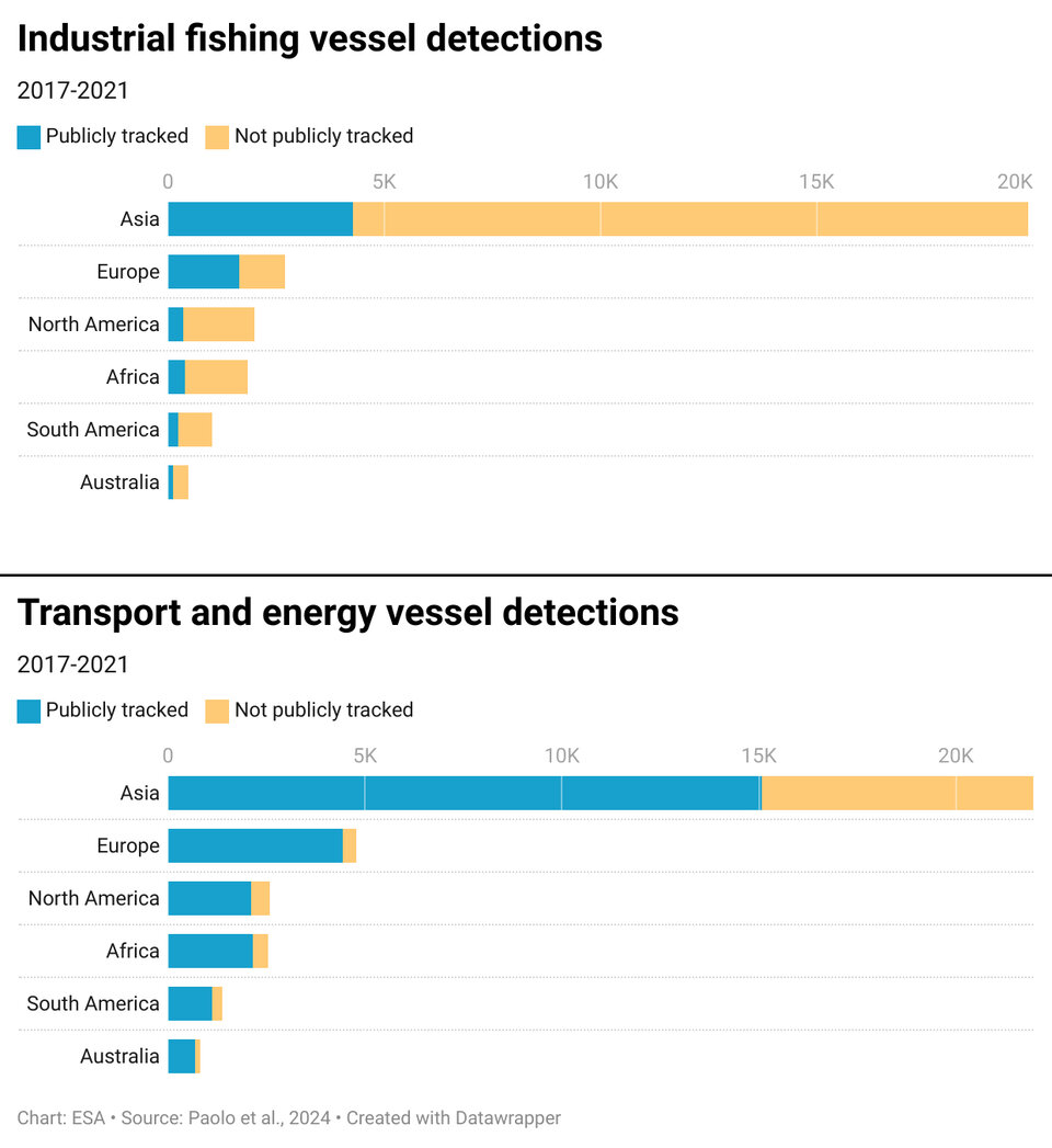
A groundbreaking study that combines satellite data and Artificial Intelligence has thrown new light on the number of vessels at sea. Astonishingly, the study reveals that around 75% of the world's industrial fishing vessels have previously been ‘dark’ to public tracking systems.
The study, published recently in the journal Nature, was led by Global Fishing Watch – an organisation that seeks to advance ocean governance through increased transparency of human activity at sea.
Not all boats are legally required to broadcast their position, but vessels not included in public monitoring systems, often termed ‘dark fleets’, can pose challenges for protecting and managing natural resources.
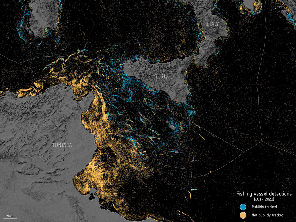
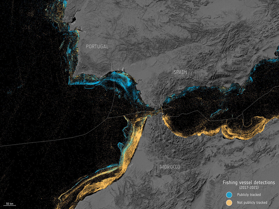
By using five years’ worth of radar data from the Copernicus Sentinel-1 mission and some optical data from the Copernicus Sentinel-2 mission along with GPS information, researchers from Global Fishing Watch were able to identify ships that had not declared their positions.
By then applying machine learning to the data, the researchers could conclude which of the vessels were engaged in fishing.
The study period spanned 2017–2021 and covered coastal waters across six continents where the vast majority of fishing and offshore infrastructure are concentrated.
They found numerous dark fishing vessels inside many marine protected areas, and a high concentration of vessels in many countries’ waters that previously showed little-to-no vessel activity by public monitoring systems.
It also transpired that more than 25% of transport and energy vessel activity was also missing from tracking systems.
“A new industrial revolution has been emerging in our seas undetected, until now,” said David Kroodsma, Director of Research and Innovation at Global Fishing Watch.
“On land, we have detailed maps of almost every road and building on the planet. In contrast, growth in our ocean has been largely hidden from public view. This study helps eliminate the blind spots and sheds light on the breadth and intensity of human activity at sea.”
Fernando Paolo, Senior Machine Learning Engineer at Global Fishing Watch, added “Historically, vessel activity has been poorly documented, limiting our understanding of how the world’s largest public resource – the ocean – is being used.
“By combining space technology with state-of-the-art machine learning, we mapped undisclosed industrial activity at sea on a scale never done before.”
Publicly-available data suggests that Asia and Europe have a similar number of fishing vessels within their relative borders – however, this is not the case.
Jennifer Raynor, Assistant Professor of Natural Resource Economics at the University of Wisconsin-Madison, said, “Our mapping reveals that Asia dominates. For every 10 fishing vessels we found on the water, seven were in Asia while only one was in Europe.
“By revealing dark vessels, we have created the most comprehensive public picture of global industrial fishing available.”
ESA’s Copernicus Sentinel-1 Mission Manager, Nuno Miranda, noted, “We are taken aback by the results of the study, I don’t think anyone expected that 75% of vessels at sea are not broadcasting their positions.
“We are extremely proud of the preponderant role played by Sentinel-1 in these astonishing results.
“The mission truly demonstrates how the all-weather, day and night imaging capacity of radar combined with its systematic and global observations allow for a better understanding of the scale at which humans are impacting the environment and natural resources.”
As well as the implications this has on targeting vessels that could be fishing illegally, these results will also help understand more about greenhouse gases being emitted at sea.
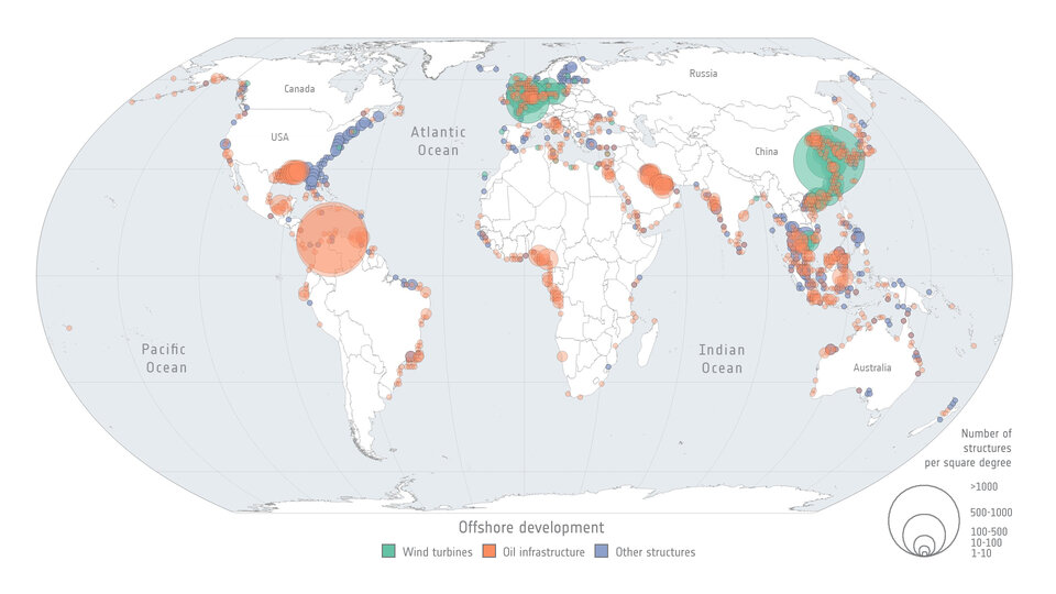
The study also looked at offshore infrastructure such as wind turbines and oil platforms.
During the study period, oil structures increased by 16% and wind turbines more than doubled. By 2021, turbines outnumbered oil platforms. China’s offshore wind energy had the most striking growth, increasing ninefold between 2017 and 2021.
This is important for helping to understand development impacts and trends.