Tap into Europe in motion
Any movement beneath our feet – from barely perceptible subsidence to the sudden appearance of a sinkhole or a crashing landslide – spells big trouble. Even relatively modest subsidence can weaken buildings and infrastructure and lead to issues such as flooding, and at worst the abrupt disappearance of sections of land brings immediate threat to life. Monitoring and predicting our shifting land is clearly essential for adopting mitigating strategies.
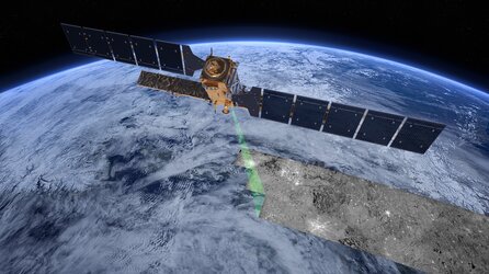
And now, thanks to Europe’s environmental Copernicus programme and the Sentinel-1 radar satellite mission, the first Europe-wide subsidence and soil movement analysis service is available to the public.

The new European Ground Motion Service, the latest offering of the Copernicus Land Monitoring Service and implemented by the European Environment Agency, provides free and accessible ground motion data to anyone who wishes to use it.
Based on radar data from Copernicus Sentinel-1 satellite mission, the service provides information on the motion of land, structures and infrastructure in Copernicus Participating States. Its aim is to give users reliable information on ground motion at a local, regional or national scale.
Radar images – as provided by the Sentinel-1 mission’s advanced C-band synthetic aperture radar – are the best way of tracking land subsidence and structural damage.
The ‘radar interferometry’ remote sensing technique combines two or more radar images from the same orbital geometry over the same area to detect changes occurring between acquisitions. Interferometry allows for the monitoring of even slight ground movement – down to a few millimetres – across wide areas.
Using these millimetre-scale measurements of ground motion, the European Ground Motion Service enables the mapping of subsidence and landslides, as well ground affected by seismic and tectonic activity.
Subsidence, for instance, is a serious concern, often caused by the removal of groundwater, oil, natural gas or mineral resources. Even modest subsidence can weaken buildings, bridges, railway lines, sewer pipes, dams and sea defences, the list goes on.
Needless to say that damage to the infrastructure on which we rely can pose danger. Repairing structures is expensive, but so too is adopting mitigating strategies. It is therefore paramount that the authorities, urban planners and construction companies, for example, have accurate information so that they plan and invest as effectively as possible.
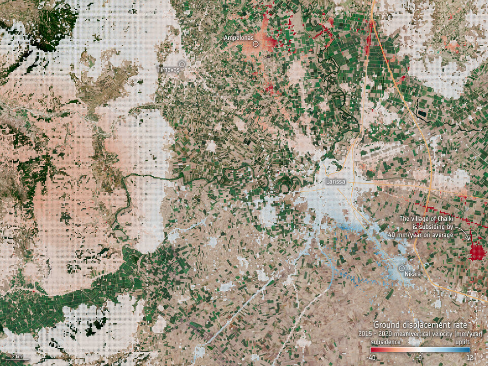
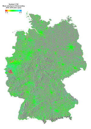
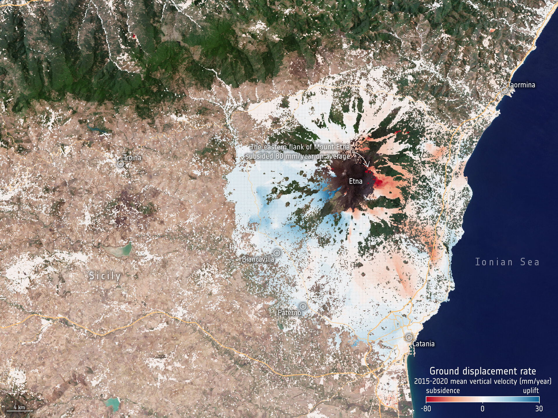
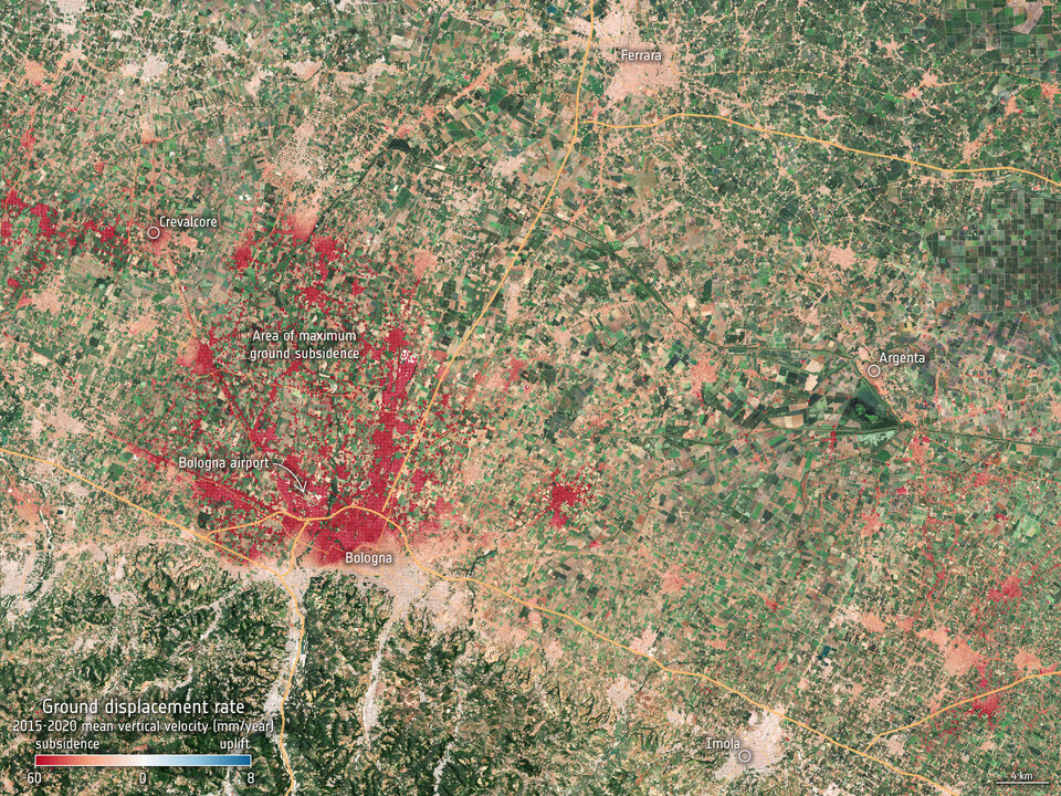
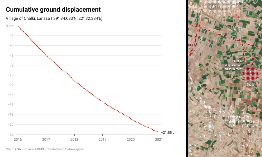
Help is now at hand through the European Ground Motion Service, which provides data on a continental scale, in the form of maps colour-coded by the velocity of ground motion, in terms of millimetres per year. The first baseline product, covering 2015–2020, is made from Sentinel-1 satellite data acquired every six days during that period.
The measurements provided by the European Ground Motion Service are valuable for many user communities. They are, for example, critical for studying, monitoring, and understanding a variety of deformation phenomena of anthropogenic origin, but also deformation resulting from seismic and tectonic activity.
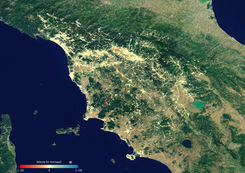
The images here are examples of data that can be accessed through the service. They depict ground motion around Mount Etna and Bologna in Italy, as well as an area around Larissa in Greece. While subsidence and uplift around Mount Etna is linked to volcanic activity, the subsidence we see in Bologna and villages near Larissa is associated with the extraction of groundwater.
In fact, among the most important and valuable applications of this new service is for risk assessments related to geohazards. Risk assessment through ground motion analyses is essential for the development of mitigation strategies and for more effective exploitation of resources, as well as for better management and planning of urban areas and infrastructures.
This new service, which was initiated by the European Union as part of the Copernicus programme, is also closely linked with other aspects of ESA’s Earth Observation Programmes such as the Geohazards Exploitation Platform. This is a research and development processing environment dedicated to terrain motion mapping that has been upgraded to allow for the visualisation of products delivered by the European Ground Motion Service. It offers further interferometric processing with complementary on-demand processing such as the SNAPPING service and the P-SBAS service that use Sentinel-1 time series.
Accessing the European Ground Motion Service on the Geohazards Exploitation Platform and combining it with complementary processing chains is intended to maximise the impact and benefit of the technology with user communities.
Beyond this, the availability of the European Ground Motion Service is intended to help increase awareness and acceptance of radar interferometry as a solution in various industry sectors on a global basis where service providers from Europe have commercial Earth observation-based capabilities using both Sentinel-1 synthetic aperture radar and very high-resolution synthetic aperture radar missions.
The European Ground Motion Service is available to the public, everyone can register on the platform and access the data.