

Earth from Space: Lusaka, Zambia
The Copernicus Sentinel-2 mission takes us over Lusaka – the capital and largest city of Zambia.
Click on the image to explore it in its full 10 m resolution and learn about the features in this stunning landscape.
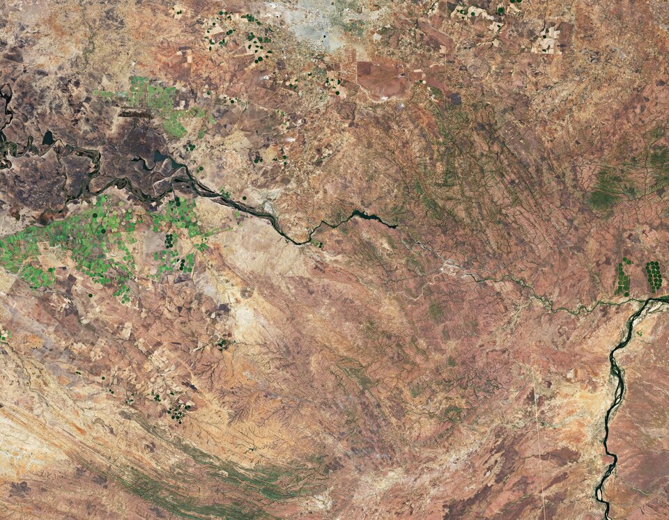
Lusaka, visible at the top of the image, is located on a high plateau in south-central Africa with an elevation of around 1200 m. With a population of over 2 million people, Lusaka is one of the fastest developing cities in southern Africa. Lusaka National Park is easily identifiable as a brown patch of land just southeast of the city. The 6700 hectare park hosts a variety of rare and endangered animals.
Owing to Zambia’s humid sub-tropical climate, agriculture is the country’s main source of income and jobs. The circular shapes in the image, visible mostly southwest of Lusaka in light green, are an example of pivot irrigation, or centre-pivot irrigation systems. This type of irrigation functions where equipment rotates around a central pivot and crops are fed with water from the centre of the arc.
Water from the nearby Kafue River, visible cutting across the image from left to right, is used for irrigation and hydroelectric power. At 1600 km long, the Kafue River is the longest river lying solely within Zambia. The river flows across the flat plain called Kafue Flats (also known as Butwa) and meanders in a maze of swampy channels and lagoons.
The flats, visible in dark brown in the far-left of the image, are a shallow flood plain around 240 km long and about 50 km wide, and are usually flooded to a depth of less than one metre in the rainy season.
From here, the Kafue River continues its journey southeast, flowing through the Kafue Gorge before finally joining the Zambezi River, visible in the bottom-right of the image, near Chirundu, Zimbabwe.
Data from the Copernicus Sentinel-2 mission can help monitor changes in urban expansion, land-cover change and agriculture monitoring. The mission’s frequent revisits over the same area and high spatial resolution also allow changes in inland water bodies to be closely monitored.
This image is also featured on the Earth from Space video programme.

Access the video

