

Envisat global land and sea level data now available
ESA is now providing scientific and industrial users with continuously updated satellite measurements of the precise contours of the land, sea and ice surfaces of the Earth.
The new Level 2 products are derived from the Radar Altimeter-2 (
The data are processed and distributed for ESA by the CLS ('Collecte, Localisation, Satellites') centre in Toulouse and the French space agency CNES ('Centre National d’Etudes Spatiales').

The resulting products provide researchers with the ability to measure ocean topography, sea ice, polar ice sheets and land elevation with unprecedented accuracy.
The
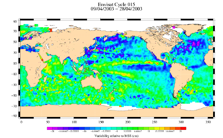
Warm ocean currents can cause sea surface height to rise up to a metre above surrounding waters, so radar altimetry provides a means of mapping the circulation of Earth’s oceans – as well as following El Niño events as they develop. Global ocean wave height and wind speed can also be measured simultaneously with the sea surface height, enabling operational sea state forecasting.

Envisat was launched into orbit at the end of February 2002. Since then engineers have been kept busy with commissioning the spacecraft’s ten instruments and refining software algorithms used to convert raw data into reliable geolocated products tailored for various specific uses.
The

"The level 2 data products allow scientists worldwide to conduct studies on ocean circulation, marine gravity, sea ice growth and distribution, land and ice topography mapping, and sea level change," explained Remko Scharroo of the Delft Institute for Earth-Oriented Space Research (DEOS), one of the
For the
So the new
And by processing

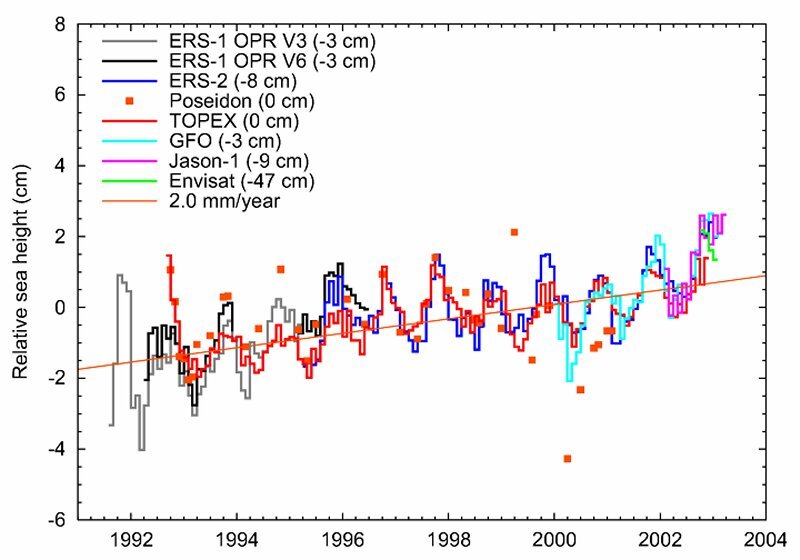
A combined ground segment specially developed by CNES for altimetry missions called SSALTO ('Segment Sol multi-mission d'ALTimétrie, d'Orbitographie et de localisation précise') is used to do this. Combining together data from altimeter-equipped satellites such as ESA’s ERS 1 and 2 and Envisat as well as TOPEX/Poseidon, Jason-1 and GFO shows an average rise in global sea level of 2 mm per year during the last decade.
The work performed is the first step in the enhancement of the Envisat data quality but not the last. Regular upgrades of the processing chain and related data products are already planned, and shall take place throughout the Envisat mission lifetime to ensure and improve the overall data reliability, quality and adequacy to user needs.
GDR and other level 2 data products are currently available via FTP site since 8 September 2003 and are also about to be receivable via DVD. The ESA Earth Observation Help Desk can provide further information on the RA-2 data availability.
