Looking forward to delivering results - Pascal Gilles, Mission Manager
Mission Manager Pascal Gilles will be in charge of CryoSat once it becomes an operational spacecraft post-launch.
After CryoSat's commissioning phase is complete he will in particular oversee routine operations, including the delivery of data to users worldwide.
In the meantime he is an integral part of the wider team preparing for CryoSat's imminent launch.
How did you begin working at ESA?
My academic background is in atmospheric physics. Coming from the Ecole Nationale de la Météorologie in France I joined ESA early in 1984, initially working on quality control of geophysical products derived from Meteosat spacecraft data. One big motivation was to move to very dynamic environment.
From France where I served as a civil servant in the Transport ministry, I moved to ESA where I discovered an international community of different cultures and different interests all focusing to the same target, which I found highly motivating.
After three years at ESOC I joined ESRIN as Head of the quality control services, concentrating on products from optical sensors from the various mainly US and Japanese missions we were supporting at the time, preparing the ground for our own ERS programme.
Then I moved to the engineering side, being responsible first for the ERS-1 ground segment integration, then after its successful launch for the management of the production involving several centres devoted to the generation and distribution of products from ERS satellite data.
In 1994 I joined the Envisat adventure, being put in charge of the implementation and operations of the six Processing and Archiving Facilities across Europe. After Envisat's successful launch I was nominated its Operations Manager, which I carry on along with my work on CryoSat.
These last 15 years have been glorious years in many ways, seeing ESRIN gather a lot of competence in terms of human resources and data – so I hope this will continue with new programmes in future.
What is your role within the CryoSat team?

My role as a Mission Manager is twofold: before the end of the spacecraft commissioning, my role is to support the Project Manager Guy Ratier based in ESTEC, in particular in interfacing with the future User community, collecting its requirements in satellite data availability and ensuring that all means are put into place to satisfy them after the satellite becomes operational.
Towards the end of the commissioning phase, after a Commissioning Results Review has confirmed that the CryoSat system is performing according to specifications and able to satisfy the mission objectives, there will be an Operational Readiness Review that will formalise the transfer of the mission authority from the Project Manager to myself, and I will be in charge of all aspects of the mission from this point on.
Who are the users of CryoSat data?
The biggest community of users are scientists interested in the altimetry data we will provide to them and will, after having calibrated and validated it by comparing it to ground data, try to identify trends in the behaviour of land ice and sea ice thickness.
Then there are those users interested in the satellite technology itself and improving the algorithms used to process the spacecraft data: many of these people are part of our calibration and validation team.
And while CryoSat's main objective is the study of land and sea ice, if satellite resources allow, the plan is to switch the sensor on over the ocean - so we have a community of meteorologists and oceanographers to be satisfied as a secondary objective of the mission, complementing ESA's ERS and Envisat radar altimetry missions and the Topex-Poseidon and Jason missions run by NASA and the French space agency CNES.

Will data from other satellites help to validate CryoSat products?
The idea is to cross-check CryoSat data with some of the other radar altimeters' data for validation. While CryoSat will go further north and south than other satellites we can crosscheck the areas that are covered by both.
It is also essential for people on the ground to collect ground-truth data we can check our products against, and the ice science community through the Lead Investigator Duncan Wingham is proving highly motivated and well-resourced to help us out with this.
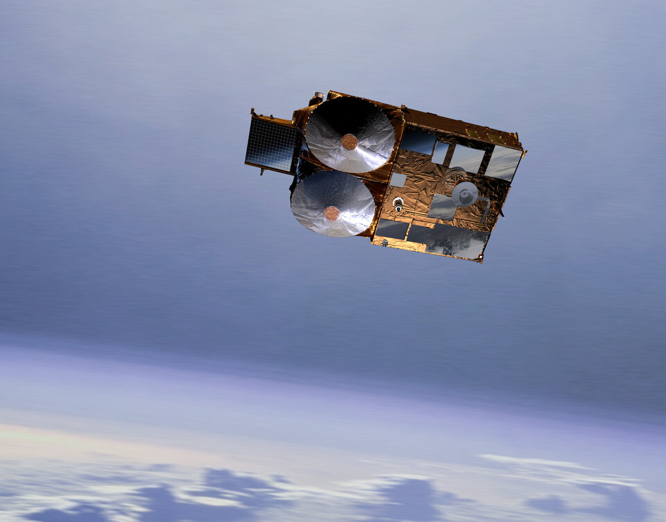
Collecting ground-truth is essential for the CryoSat mission. CryoSat is an experimental satellite, so that as we look at the ground and make measurements, we are not exactly sure of what we are seeing. There is a theory, but we need to ensure we are measuring the ice and not the snow level, and all those algorithms used to derive the proper data need to be properly consolidated, ground-truth data being essential to do that.

Once this experimental sensor is launched, what will we get?
Before the turnover we will have verified CryoSat products, however further validation will go on throughout the lifetime of the satellite. The first two years shall be very fruitful in finding out a lot of things, and also in measuring the mean sea surface levels of those areas of the ocean not previously covered by ESA satellite data: if you look at images of the North Pole or Antarctica taken by Envisat or ERS you see a big empty hole over the centre, the size of hole will be much reduced with CryoSat data.
We need to collect data and evaluate mean sea surface level over these areas so as to allow us to measure the sea ice freeboard and subsequently deduce the overall amount of floating sea-ice.
Then after those two years there should be consolidation of the processing algorithms and we will carry out a complete reprocessing exercise, aiming at providing us eventually with a coherent set of data over the entire mission.
How will CryoSat data make its way to its users?

The CryoSat ground segment has been developed under the responsibility of the Project, but operating it will be the responsibility of the Ground Segment Department in ESRIN during the exploitation phase. The ground segment is substantially simpler than for a large mission like Envisat, but still contains all the elements necessary to plan satellite and payload activity to acquire the data, process the data, archive it and deliver it to users.
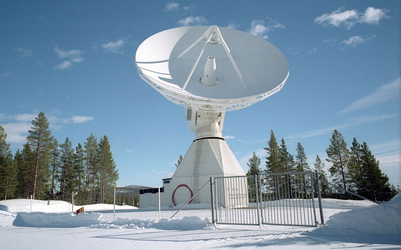
We will be relying on a single ground station in Kiruna to downlink data, process it and deliver it to users, and on a single long-term data archive located in CNES, rather than the complex ground segment distributed across Europe we have for Envisat. CNES has a long-recognised competence in radar altimetry and is handling the Radar Altimeter-2 archive for Envisat, so it was a natural decision.