A broader view of Deuteronilus Cavus
This map shows the 120 km-wide Deuteronilus Cavus depression in context with its local surroundings in the northern mid-latitudes of Arabia Terra on Mars.
The name Deuteronilus is derived from Greek and means ‘second Nile,’ referencing the nearby Mamers Valles, which stretches over 1000 km. The valley intersects Deuteronilus Cavus to the east.
The crater is situated in the transitional zone between the planet’s rugged southern highlands and smoother northern lowlands. This entire region is characterised by a complicated mix of features collectively known as ‘fretted terrain’. This includes knobs, mesas, meandering channels and buried ice.
As such, Deuteronilus Cavus preserves a rich geological history from its formation some four billion years ago, through to more recent erosion by water and ice, as well as volcanic activity and wind.
The area outlined by the larger white box indicates the area imaged by the High Resolution Stereo Camera aboard ESA’s Mars Express orbiter on 25 October 2024 during orbit 26275, while the smaller white box shows the part of the surface featured in these new images.
The colours refer to elevation (see image for key).
[Image description: A map with gridlines spanning coordinates 20–50 degrees North and 0–30 degrees East on Mars. Two long rectangular white boxes are positioned close to the centre of the image in a north-south direction. The larger box outlines an area imaged by ESA’s Mars Express during a particular orbit on 25 October 2024. The small box shows the region highlighted in the associated image release. The map is colour-coded to represent elevation.]

Deuteronilus Cavus in 3D

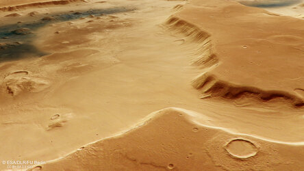
Branched channel at Deuteronilus Cavus on Mars
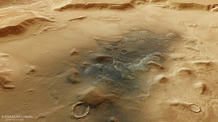
Jumbled blocks and dust on the floor of Deuteronilus Cavus

Topography of Deuteronilus Cavus on Mars