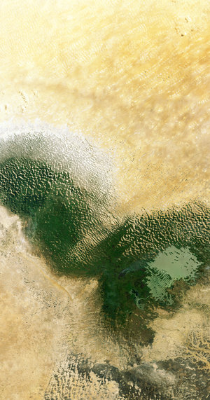
Desert structure in Chad
ESA revealed the first stunning images from its groundbreaking Biomass satellite mission – marking a major leap forward in our ability to understand how Earth’s forests are changing and exactly how they contribute to the global carbon cycle.
While Biomass’ longwave length P-band radar can penetrate through the forest canopy, this novel radar can also offer opportunities to explore other aspects of our planet. For example, the radar is expected to be able to penetrate through dry sand by as much as five metres. Data from the mission will, therefore, be used to map and study sub-surface geological features in deserts, such the remains of ancient riverbeds and lakes. This will help understand the past climate and also help prospect fossil water resources in desert regions.
Indicating that this can indeed be achieved, this image shows the stunning structure of part of the Sahara Desert in Chad. This image covers part of the Tibesti Mountains, a mountain range in the central Sahara, primarily located in the extreme north of Chad.
The image spans approximately 100 km along the Biomass satellite's flight path (length) and 60 km across in width, with north oriented to the top.
Read full story: Biomass satellite returns striking first images of forests and more