Severe flooding in Sumatra, Indonesia
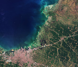
This image by Copernicus Sentinel-2 was captured on Saturday, 29 November 2025, over a region east of the city of Lhokseumawe, on the northern coast of Aceh province on the island of Sumatra, Indonesia.
Zoom in to explore this image at its full resolution.
Severe flooding was caused by heavy monsoon rains across the region, with flash floods and overflowing rivers displacing local populations and submerging neighbourhoods.
During the same period, Sentinel-2 also pictured flooding in Sri Lanka.
The Copernicus Sentinel-2 mission is based on a constellation of two identical satellites in the same orbit but on opposite sides of the globe. Each satellite carries an innovative wide swath high-resolution multispectral imager with 13 spectral bands.
Orbiting at an altitude of 786 km, the mission passes over the same location on Earth every five days and is often called upon to provide data to support emergency reponse efforts. The Disasters Charter, which turns 25 this year, has been activated to provide satellite data over Indonesia.