Seeing the satnav for the trees
ESA turned to the academic world to sharpen its understanding of how woodland vegetation can negatively affect the performance of satellite navigation systems.
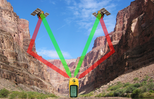
Most satnav users will have had the experience where the blue circle indicating their location suddenly expands to be a lot larger, meaning their precise position has become more uncertain.
Its leading cause is satnav signal ‘multipath’ – meaning the satellite signals bounced off surrounding surface features like echoes on their way to the receiver, which the receiver still picks up and processes as if they are coming directly from a satellite.
Various methods are used to reduce the effects of multipath, from simply disregarding signals that appear to come from very low elevations for miniature smartphone receivers up to advanced signal processing and carrier phase measurements in the case of larger, more capable satnav terminals.
In addition, researchers continue to study and model multipath effects to try and improve mitigation techniques in future.
“We have several models for multipath propagation within urban areas, where satnav signals are reflected by the sides of buildings,” explains Roberto Prieto Cerdeira, R&D Principal Engineer of ESA’s Global Navigation Satellite System Evolution Programme.
“Around a decade ago when Galileo – Europe’s own satnav system – was being designed, multipath simulations were put together for different user environments: urban and suburban areas, as well as open countryside areas.
“When the first Galileo In-Orbit Validation performance tests were carried out, we found that signal attenuation in vegetated areas that was not fully anticipated by these original simulations – often linked to places with lots of trees, such as woodland-crossing roads or tree-lined avenues.”

It was a question that deserved further research – so ESA’s Wave Interaction and Propagation section made use of the Agency’s Networking/Partnering Initiative (NPI), intended to harness advanced academic research for space applications.
Researcher Frank Schubert of the DLR German Aerospace Center, who also worked on his PhD with Aalborg University on multipath modelling, had his research supported through NPI.
“NPI gave me the possibility to access the vast experience of ESA's staff in wave propagation – together with DLR's expertise, its measurement data, and the support of the researchers at Aalborg Univerity for the analytical modelling made the dissertation a success.”
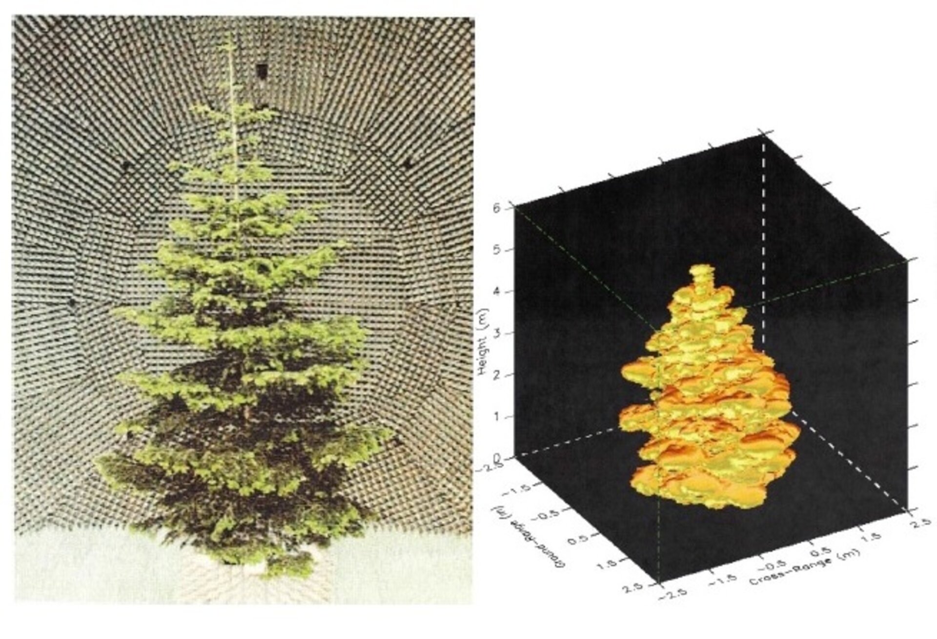
“Previous models assumed that trees would attenuate the signals – weakening them, in plain language,” says (the now) Dr Schubert. “But the actual situation turned out to be more complicated – in fact, trees scatter the incoming signals from the satellites, potentially leading to a lot of error from such multipath propagation.
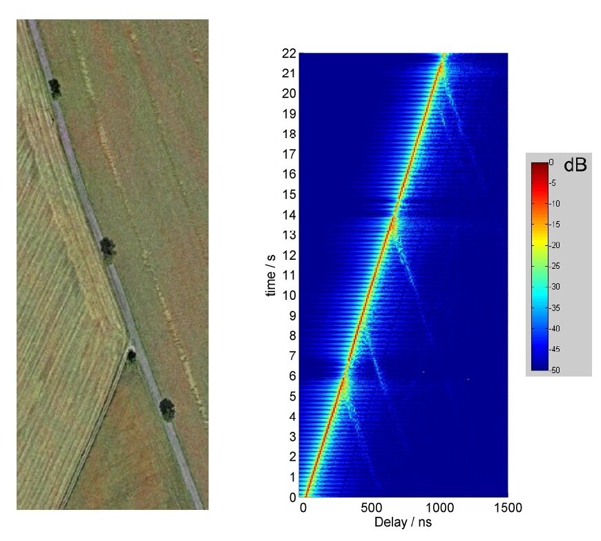
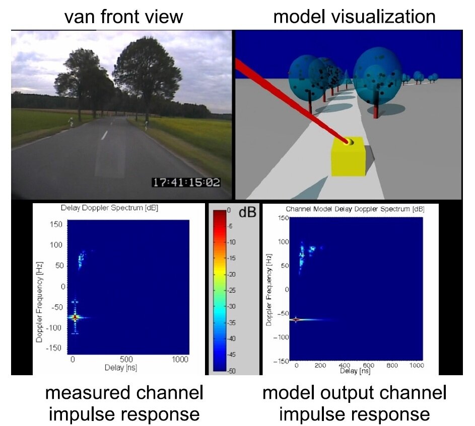
“What I needed to do was focus on the exact mathematical description of the scattering caused by single trees and how it changes as the receiver moves, so we went back to the DLR experimental data, which was based on the region around their Oberpfaffenhofen facility. The results gained from them for single trees can be used to also explain multipath propagation caused by forests and tree-lined avenues.
“You could take satellite images from sites like Google Earth and match it quite clearly to the signal measurement that had been performed on a given roadway.
“This multipath effect will have a higher impact for the slowest users, such as pedestrians, compared to more dynamic users such as car drivers – so anyone having trouble with their positioning accuracy might try to head away from nearly woodland.
“In the future, the developed model will help satnav receiver designers to avoid the multipath effects caused by vegetation.”
Through NPI, he eventually spent almost a year at ESA’s ESTEC technical centre at Noordwijk in the Netherlands, allowing him to tap into Agency expertise.
Frank is now working on satnav signals and receiver design at Airbus Defence and Space, while his research has led in turn to follow-up European research into multipath modelling and mitigation.
The observations and results obtained during this NPI work will be instrumental for system performance assessment in forest and areas covered by trees for Europe’s next-decade Galileo second generation system.