Aeolus operations
Editor's note: This page is no longer being updated, but will be preserved as a record. Click here for the latest information on Aeolus.
Launched on 22 August 2018, Aeolus is the fourth Earth Explorer mission to be developed within ESA's Living Planet Programme. The first-ever satellite to directly observe wind profiles from space, Aeolus was launched on a Vega rocket from Europe's Spaceport in Kourou, French Guiana.
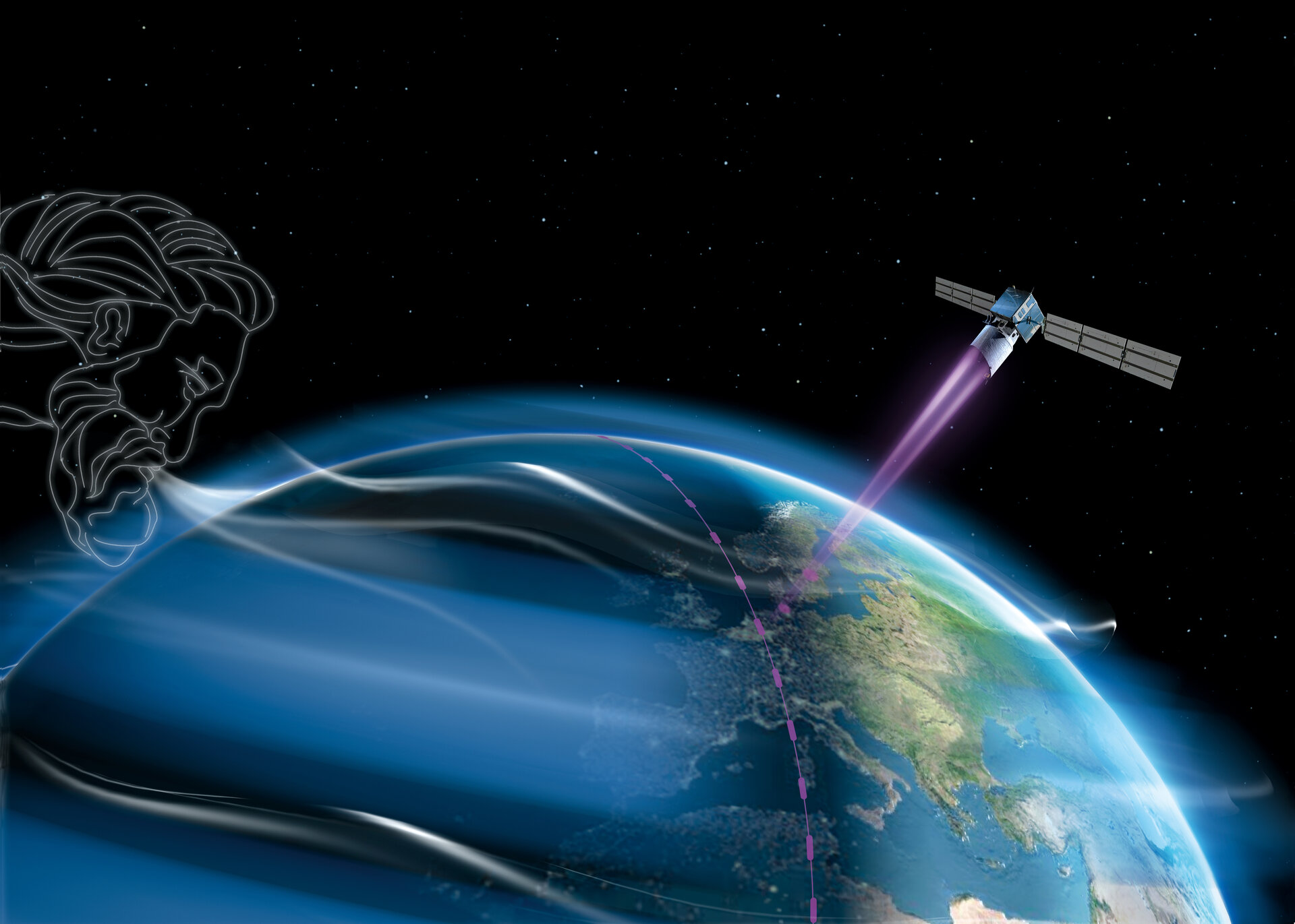
Named after Aeolus, who in Greek mythology was appointed 'keeper of the winds' by the Gods, this mission provides the much-needed data to improve the quality of weather forecasts as well as contribute to long-term climate research.
The mission
Although weather forecasting has advanced considerably in recent years, meteorologists still need reliable wind-profile data to further improve the accuracy of forecasts. ESA's wind mission, Aeolus, aims to demonstrate that measuring global wind profiles from space, using laser technology, can meet this requirement.
The Aeolus Flight Operations Control Centre (FOCC) is being established at ESOC, Darmstadt, Germany.
| ROLE | Earth observation (EO) |
| LAUNCH DATE | 21 August 2018 |
| LAUNCHER/LOCATION | Vega/Kourou |
| LAUNCH MASS | 1360 kg (estimated) |
| ORBIT | Sun-synchronous, dawn-dusk; 320 km |
| NOMINAL MISSION | 3 years |
| + Global wind observations to improve weather forecasts and advance understanding of atmospheric dynamics & climate + | |
The Flight Control Team
The Aeolus Flight Control Team operates from a Dedicated Control Room located at ESOC.
The Aeolus team is responsible for command and control, on-board software maintenance and mission planning, as well as interfacing with other ground segment teams. As with all satellites operated from ESOC, specialists from other support teams including Flight Dynamics, Ground Facilities and Software Support contribute to the mission on a daily basis.
Mission operations overview
The main aim of the mission is to further our knowledge of the Earth's atmosphere and weather systems.
By recording and monitoring the weather in different parts of the world, Aeolus allows scientists to build complex models of our environment, which can then be used to help predict how that environment will behave in the future.
The Aeolus satellite carries one large instrument, the Atmospheric Laser Doppler Instrument (ALADIN), which probes the lowermost 30 km of the atmosphere from 320 km above the Earth's surface. The satellite creates the first-ever series of consistent global wind profiles giving meteorologists better information with which to predict weather. From orbit, Aeolus is able to provide global wind profiles, including remote areas lacking ground-based weather stations.
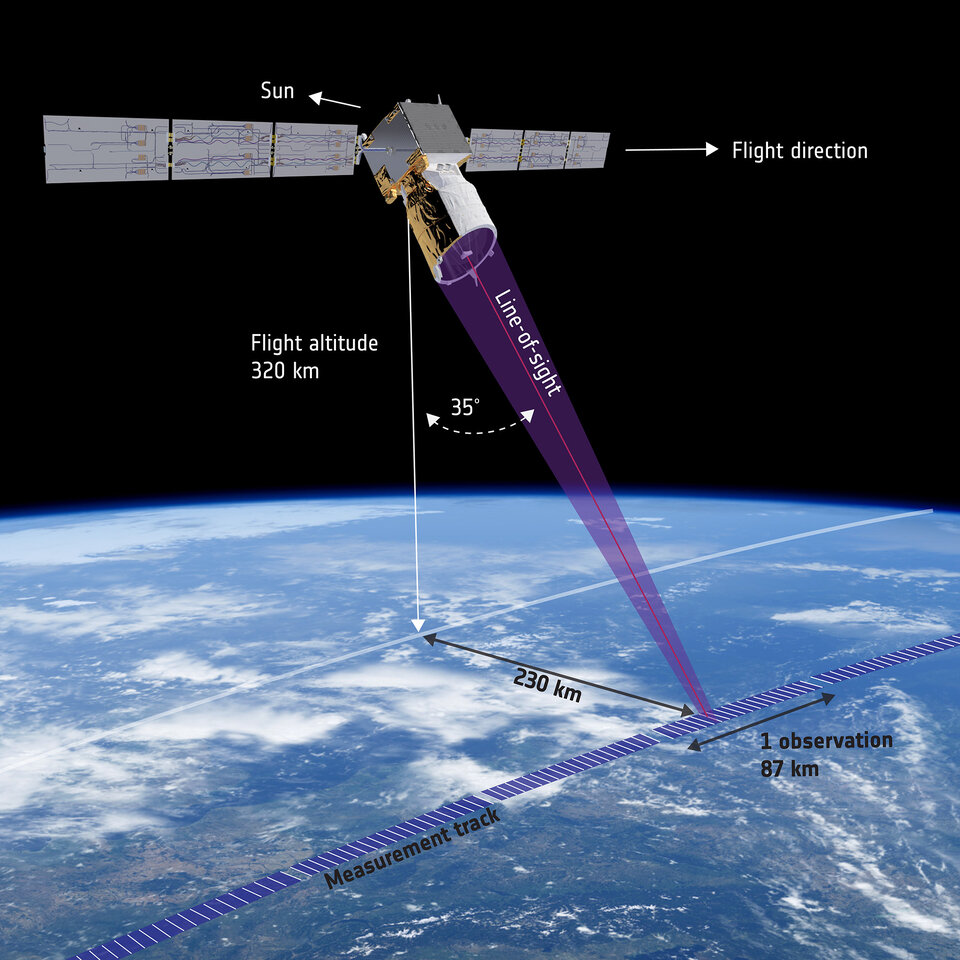
Aeolus flies in a rather low Sun-synchronous orbit at about 320 km altitude in a dusk-dawn orbit. Winds are measured orthogonal to the flight direction at an angle of 35 degrees off-nadir on the night side of the Earth.
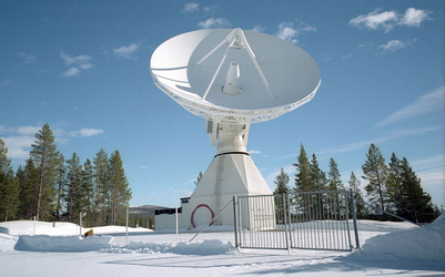
The concept for control of the Aeolus mission is based on the use of a single ground control centre in conjunction with ESA's ESTRACK ground station in Kiruna. The Launch and Early Orbit Phase (LEOP), as well as the Commissioning Phase, was supported for tracking, telemetry and telecommand by additional ESTRACK ground stations as well as Svalbard and Troll.
All routine payload operations are preplanned and executed according to the Flight Operations Plan (FOP). Payload operations as well as science data downlink activities are scheduled for autonomous execution on board based on the spacecraft position along the orbit. There are no real-time platform operations other than near real-time interactive activities at the time of commissioning (initial equipment turn-on, calibration), when uploading regular orbit maintenance manoeuvres or during contingency situations.
The ground stations - Kiruna, Svalbard
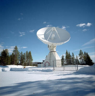
For real-time housekeeping telemetry downlink and telecommanding during routine operations, Aeolus uses ESA's ESTRACK ground station in Kiruna. The TC link (uplink) at 2030 MHz (S-band) at 2 Kbps, while the housekeeping TM downlink at 2205 MHz (S-band) is at 8 Kbps.
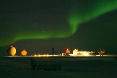
For science data reception Svalbard and Troll X-band stations are used, with science data received using 8040 MHz (X-band) at 10 Mbps.
Ground segment & mission control system
The Ground Segment is composed of:
- The Flight Operation Segment (FOS): responsible for spacecraft commanding, health monitoring, orbit control and onboard software configuration and maintenance. This includes the uplink of instrument operation time lines as well as the provision of scientific data downlink schedules based on the predicted spacecraft orbit. The FOS is operated from ESOC/Darmstadt, Germany;
- The Payload Data Ground Segment (PDGS): responsible for mission data acquisition and mission planning, processing of scientific data, archiving and distribution of scientific data to the Meteorological Centres and the general scientific community.
-
- House keeping data (HK) is downlinked in X-band together with the science data at the KSAT Svalbard (Arctic) and Troll (Antarctica) stations.
- L0-L1-L2A data processing in Near Real Time is performed at KSAT/Tromsø, Norway, while wind profile retrieval (L2B wind products) and L2C assimilated wind products generation is done by the European Centre for Medium-Range Weather Forecasts (ECMWF), UK.
- The PDGS is managed from ESRIN for the complete mission duration (launch up to the end of mission, when ground contact to the spacecraft/payload is terminated).
The platform and payload
The platform
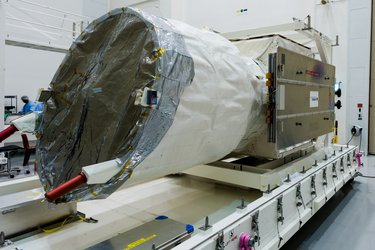
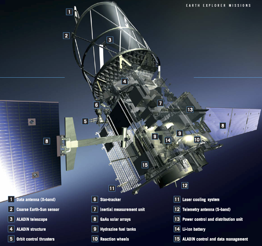
The satellite weights 1360 kg, comprising the satellite platform (650 kg, plus 266 kg propellant) and the payload (450 kg).
In launch configuration, the dimensions are: height 4.6 m, length 1.9 m, width 2.0 m. The solar arrays (2x3 panels) will provide 2.4 kW power at end of life.
Attitude control is maintained using reaction wheels, magnetotorquers and thrusters. On-board navigational and attitude sensors include a coarse Earth-Sun sensor, a magnetometer for coarse pointing control, a star tracker and an inertial measurement unit, as well as GPS for fine pointing control.
The payload
Aeolus carries a single payload, the Atmospheric Laser Doppler Instrument (Aladin) - a Direct Detection Doppler Wind Lidar operating at near ultraviolet (UV) wavelengths (355 nm). It comprises two main assemblies:
- Transmitter: diode pumped Nd: YAG laser, frequency tripled to 355 nm, 70 mJ output energy, 50 Hz pulse repetition frequency.
-
Receiving telescope: Cassegrain, SiC technology, 1.5 m diameter.
Instrument receivers: Mie spectrometer (Fizeau interferometer, measuring atmospheric backscatter from aerosols and water droplets), Rayleigh spectrometer (double-edge Fabry-Perot etalon, measuring atmospheric backscatter from air molecules)
ALADIN is an active instrument which fires laser pulses toward the atmosphere and measures the Doppler shift of the collected return signal, backscattered at different levels in the atmosphere.