

Mapping planet Earth for better positioning: ESA’s GENESIS mission
ESA’s Navigation Directorate is planning a new satellite whose results will enable the generation of an updated global model of Earth – the International Terrestrial Reference Frame, employed for everything from land surveying to measuring sea level rise – with an accuracy down to 1 mm, while tracking ground motion of just 0.1 mm per year. This improvement, at a stroke, will have a major impact in multiple navigation and Earth science applications, including enhancing the precision of the Galileo navigation system. This mission, called GENESIS, is being proposed to ESA’s Council Meeting at Ministerial Level next month.
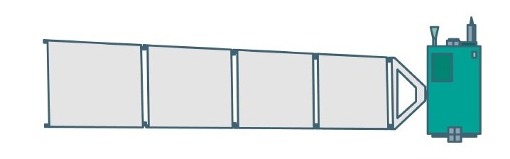
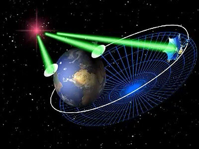
GENESIS will work by combining and co-locating all four of the main technologies currently used for Earth geodetic measurement on the same platform for the first time, aboard a satellite in a 6 000 km altitude orbit. In the process this satellite will also obtain one of the most precisely determined orbits of any object in space, right down to millimetre scale.
“Measurement is all about accurate points of reference,” explains Javier Ventura-Traveset, the Head of ESA’s Galileo Navigation Science Office.

“Thanks to GENESIS we will enhance the accuracy of the Earth space reference system by around an order of magnitude. This is essential for positioning and navigation in the civil society and for proper georeferencing of all geospatial information. GENESIS will also allow enhancing the ‘precise orbit determination’ of Galileo and other satellites, and in turn immediately improve their positioning performance, because we will have a truer reference for the exact distances that their signals are travelling from space to the ground.”
As well as improving our knowledge of the orbits of Galileo – and other Global Navigation Satellite System, GNSS satellites – the data gathered by GENESIS will also allow ‘phase centre calibration’ of GNSS antennas, identifying the offset between their mechanical and electrical centres, which plays a key role in many aspects of positioning, navigation and timing.
In addition, the highly accurate orbital tracking that GENESIS needs to perform its mission, will enable one of the most accurate modelling yet of the non-gravitational forces acting upon satellites in space – such as solar radiation pressure, which is the slight but steady push that objects in orbit receive from sunshine itself.
GENESIS itself will be a relatively small metre-scale satellite, but the challenge will be to synchronise and cross-calibrate its quartet of payloads in a very stable environment, mapping their positions relative to the satellite’s centre of mass down to a millimetre or less during the whole duration of the mission.

A new view of our home planet
Equivalent benefits will also accrue to many other space missions, such as the radar altimetry satellites employed to track sea level rise, as well as Earth-based sciences and location-based services.
Javier adds: “Thanks to GENESIS we will improve the current accuracy of the International Terrestrial Reference Frame (ITRF), which is the foundation for all space and ground-based observations in navigation and the Earth sciences and, therefore, its improvement will provide major benefits in all related applications. The results from GENESIS will also strengthen many location-based services in everyday life, such as land surveying, intelligent transportation systems, precision agriculture and infrastructure maintenance.”
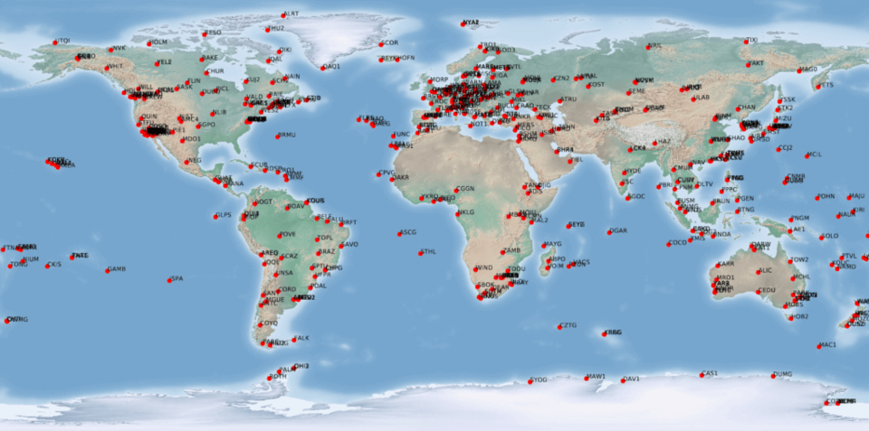
The ITRF is built up in turn from a grid of specific reference points: Global Geodetic Observing System stations spaced around the globe whose positions are precisely and regularly mapped using a quartet of space-based geodetic techniques.
Javier adds: “The problem is that when combining all these methods for ITRF generation, they are affected by the accuracy on which we determine the differential coordinates between the reference points of each technique, the so-called local-ties, and by some systematic errors, building up the overall error level.”
“But now by operating all of them together from the same satellite, with the instruments duly calibrated and synchronised, we can identify and correct for these biases over time, reaching much more accuracy and stability overall. GENESIS will in turn become a dynamic space geodetic observatory, which efficiently complements the existing ground-based infrastructure, providing a breakthrough in improving the accuracy and consistency of the Earth reference frame.”
Combined scientific measurements
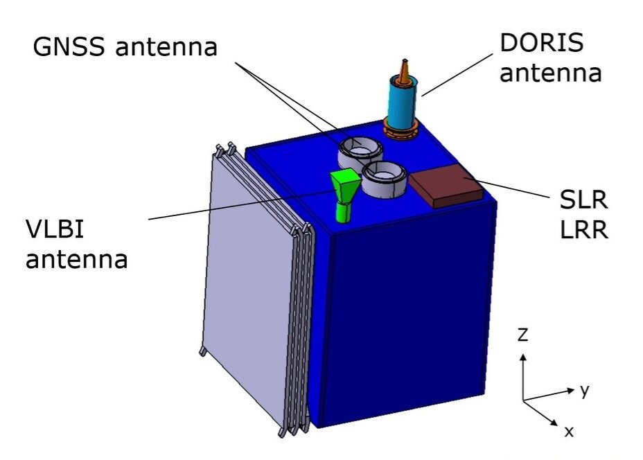
GENESIS will embark the following geodetic payloads, today used to fix the position of observing stations:
| Global Navigation Satellite System receiver | Satellite navigation, otherwise known as satnav, is one of the most widely-used geodetic techniques. Positioning of a given site is fixed continuously, using multiple satnav constellations for added accuracy, and over time becomes more and more precise down to millimetre scale, additionally revealing gradual drifts due to Earth movement. |
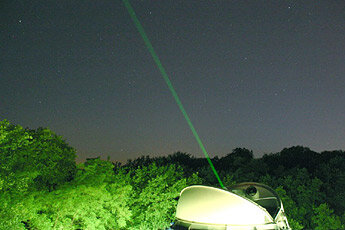
| Satellite Laser Ranging | This measurement method involves bouncing laser pulses off a retroreflector aboard a satellite, then measuring its two-way travel time to fix the distance the laser light has shone, down to a few millimetres. |
| DORIS receiver | France’s Doppler Orbitography and Radiopositioning Integrated by Satellite or DORIS system has been in operation for the past three decades and has become a standard data source for the ITRF. DORIS signals from satellites are compared to those coming from 60-strong receiver station network spaced across the planet in terms of their ‘Doppler shift’ – rising in frequency upon approach and sinking when moving away – to fix their relative position down to centimetre scale. |
| VLBI | Very Long Baseline Interferometry, or VLBI, began as a radio astronomy technique where observations of celestial objects such as quasars from multiple radio telescopes are combined together precisely to yield resolution equivalent to a single giant telescope. For geodesy the technique can be reversed so that the precise timings of joint observations of celestial targets can derive the exact distance between the sites. An artificial radio source aboard GENESIS will therefore serve as a common target for multiple VLBI stations down on Earth, broadcasting on at least two frequency bands. |
One or more of these instruments, once duly qualified and characterised with the GENESIS mission, could also potentially be flown on future Galileo satellites.
Strong scientific and international support
Following the publication of a scientific white paper and ESA’s recent GNSS Scientific Colloquium in Sofia, Bulgaria, the proposed mission has received very strong support from the scientific community as well as interest from NASA.
Furthermore, the potential of this mission was also acknowledged recently during the UN International Committee on GNSS 16th Meeting in Abu Dhabi on 9-14 October, where the wide range of benefits of this mission for precise navigation, Geodesy, Earth science and climate change monitoring were highlighted.
A recent ESA ‘Request for Information’ for the GENESIS mission was published to gather further inputs from industrial partners who could undertake the mission, once approved.
Forward to FutureNAV
GENESIS is supported through the ESA Directorate of Navigation’s FutureNAV programme, which also includes In-orbit Demonstration satellites for a low-Earth-orbit satnav constellation. The FutureNAV programme, including GENESIS, is up for decision at ESA’s next Council at Ministerial Level in November.