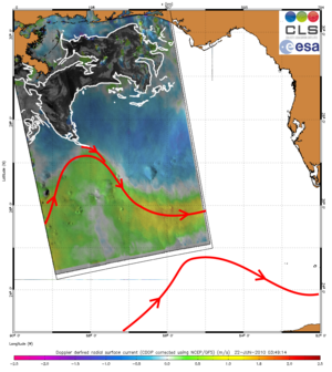
Image of the day: Oil still entering Loop Current
This Envisat radar image acquired over the Gulf of Mexico on 22 June 2010 shows that the oil spill (outlined in white) has radiated all over the Gulf of Mexico basin and is also continuing to feed into the Loop Current (red arrow).
"This is a new piece of evidence of the seemingly strong attracting power of the intense Loop Current in this area," said Dr Bertrand Chapron of Ifremer, the French Research Institute for Exploitation of the Sea. "Based on the striking analogy between different observations, we can confirm that part of the spill is more or less continuously trapped with this intense current which will radiate the pollution over the southern part of the Gulf."
Dr Chapron and Dr Fabrice Collard of France's CLS have been combining surface roughness and current flow information with Envisat Advanced Synthetic Aperture Radar (ASAR) data to monitor the oil spilling into the Gulf of Mexico after a drilling rig exploded and sank off the coasts of Louisiana and Mississippi, USA, on 22 April.
By performing dedicated processing methods on the images to display surface features like variations in roughness and velocity, observations now provide insight into the spatial structure of the spill and its transport by surface currents. On 18 May, a long tendril of the oil spill was detected extending down into the Loop Current.
"Using surface current analysis from ASAR data, we have identified a progressive cutoff in the Loop Current evolving into a large eddy separated from the main stream," Dr Collard said. "If confirmed in the days to come, this would mean that part of the oil spill is still attracted by the strong cutoff eddy generated by the Loop Current (as observed in the image above), but still remain contained within the Gulf of Mexico."
"The influence of the general variable circulation is visible in this image. Interestingly, the finger-like shaped patterns seen flowing southeast are quite similar between this image and analysis from a month ago," Dr Chapron said.
Dr Chapron and Dr Collard created these products using ASAR in Wide Swath mode. They have been working with radar data for many years and have developed sets of algorithms that allow ASAR data to be processed in near-real time and to produce state-of-the-art ocean parameters.
These are made widely available on the SOPRANO ocean products demonstration website developed with ESA.