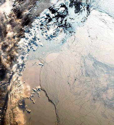
Ice monitoring
Ice extent waxes and wanes to a remarkable extent during the Earth’s annual journey around the Sun. Arctic sea ice can stretch across 14 to 16 million km2 during permanent darkness, drawing back to half that in the summer months. But winter or summer there are always people close to the ice edge who require regular updates of its precise boundaries.
With the fall of the Soviet Union in 1991, the northern sea route through the Arctic opened up to western traffic. It cuts transit time for ships running between Europe and the Pacific by about 10 days, and provides access to Arctic oil fields, but it is not a route to be taken lightly.
Even in summer, only ice-class ships supported by icebreakers can make it through. In winter it is only the western part of the route that can be used, as far as the mouth of the Yensei river, the gateway to Siberia.
To help guide ships the Russian Transport Ministry constantly collects data on ice movement from land stations, ships and aircraft. In 1995 ESA signed an agreement with the Russian Space Agency known as ‘Icewatch’, providing experimental satellite monitoring of the route using Envisat’s predecessor ERS-1.
SAR radar data was faxed to convoys led by icebreakers, allowing them to avoid the thickest ice. An oil company carrying out a seismic survey in the ice-filled Greenland Sea was also faxed ERS data on a three-hour timescale, fast enough to avoid ice moving with a maximum speed of 15 km a day.
Envisat’s ASAR radar is able to simultaneously cover an area of the Arctic four times larger than ERS’s SAR. It is also better able to distinguish between different types of ice, with a variable angled and polarised radar beam. So Arctic ships can get a wider view of the ice around them, tell whether it is solid pack-ice or just thin ‘pancake’ ice, and adjust their position accordingly.
Climatologists are also very interested in Envisat’s ice-monitoring abilities, to try and gauge how global warming affects the polar regions. The RA-2 Altimeter can measure sea ice and glacier thickness, featuring a new ‘four-wheel-drive’ design which enables it to keep better signal contact during previously-difficult transitions between ice, land and sea.
Experimental evidence on the ground suggests sea ice is thinning. RA-2 data, combined with earlier ERS findings, can provide a second opinion. Of course melting sea ice will do nothing to alter sea levels – they are already floating on the sea - but less sea ice means the polar regions would warm up disproportionately, and if the ice sheets of Greenland and the Antarctic begin to melt because of this, that’s a different matter.
The world’s sea levels would rise 70 m if they all melted together. Climatologists do not think that likely, but ASAR interferometry will allow them to note the slightest ice sheet retreat or advance overtime.