Cloud-free crop maps foster sustainable farming
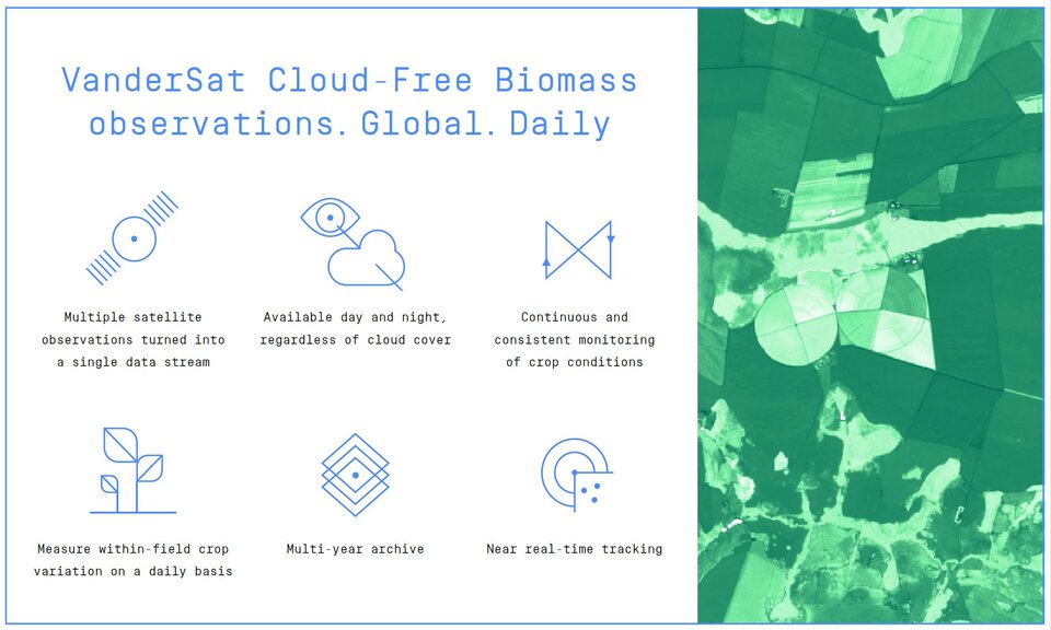
The rapidly rising global population, sustainability and climate change are among the challenges the agriculture sector faces in the business of producing food. Fortunately, information from satellites can help. A new commercial service – the first in the world – cleverly combines radar data from Copernicus Sentinel-1 and optical data from Copernicus Sentinel-2 to offer daily maps of field-scale crop biomass. Importantly, these maps are completely unimpeded by cloud cover. This new service allows farmers to better monitor and assess the growth of their produce, and, ultimately, make more effective decisions.
The service is the result of a collaboration between VanderSat and BASF Digital Farming GmbH, and sees the integration of VanderSat’s innovative Cloud-free Biomass product with BASF Digital Farming’s xarvio™ Field Manager.
VanderSat incorporates satellite data into products and services focused on the management of crops and water resources. The xarvio Field Manager, which is already used by more than 40 000 farms around the world, is a digital application that combines knowledge and data on fields and crops for plot-specific management.
Richard de Jeu from VanderSat said, “We are really excited to have had the opportunity to cooperate with BASF Digital Farming and to provide the Cloud-free Biomass service to xarvio farmers and clients, who, under the commercial agreement, will be the first to benefit.

Access the video
“There is no other globally-available and fully-operational product that observes biomass with this revisit time, accuracy and spatial resolution.”
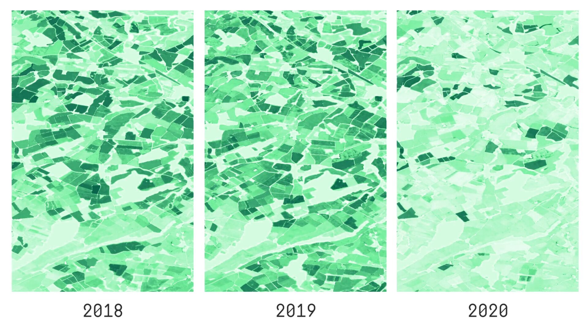
Cloud-free Biomass incorporates three different products: VanderSat’s patented retrieval method for passive microwave technology, which is based on soil moisture data from ESA’s SMOS mission and NASA’s SMAP mission, active radar images from the Copernicus Sentinel-1 mission and optical images from Copernicus Sentinel-2. VanderSat then uses its expertise in remote sensing to interpret the output from these combined data sources to provide a crop biomass indicator at a resolution of 10 x 10 metres.
“We combine radar technology, both passive and active, with optical satellite images to continually measure biophysical parameters and water content in vegetation, which accurately calculates all stages of crop growth during the entire growing season,” said Benjamin Aouizerats, Head of Research and development at VanderSat.
The service builds on the long-term cooperation between ESA and BASF to evaluate how satellite-derived data and images can be best used for agricultural purposes. Working closely with farmers, the goal was to translate this information into digital tools and services to optimise agricultural practices.
Josef Aschbacher, Director of ESA’s Earth Observation Programmes, said, “The launch of the Cloud-free Biomass service is, indeed, good news for the agriculture sector. With major concerns about climate change and the rising global population, efficient farming practices are more important than ever.
“Moreover, the way VanderSat and BASF Digital Farming have been able to combine different types of satellite data to achieve cloud-free coverage for the service is a game-changer – a prime example of science being turned into a commercial product.”
Images from satellites carrying optical ‘camera-like’ instruments can be used to measure spectral greenness and to subsequently derive a measure of ‘normalised difference vegetation index’, NDVI. However, these satellite images can only be captured during daylight and when the skies are free of cloud. In some parts of the world such as Western Europe, the daytime skies can be cloudy as much as 70% of the year. And, at times, it can take more than two weeks to receive cloud-free images of a particular area.
Also, growth underneath the crop canopy cannot always be detected. This is clearly less than optimum if you are a farmer trying to monitor crop conditions, which can change very quickly in the growing season.
The beauty of the Cloud-free Biomass service is that it combines optical images from Sentinel-2 with radar images from Sentinel-1 mission, which has the advantage of being able to image regardless of daylight or cloud cover.
ESA’s Benjamin Koetz said, “We are pleased to see the launch of the innovative cloud-free biomass crop service, showcasing the benefits of research and innovation transfer into commercial applications. Based on latest digital tools and a remarkable way of combining radar and optical satellite data, this new service means that farmers will no longer have to worry about whether it is cloudy or not when they need timely information from space about their crops.”