Sentinel-1 mission… did you know?
The Sentinel-1D satellite is ready to launch tomorrow (Tuesday 4 November) and, when it is fully commissioned, it will work with Sentinel-1C to capture high-resolution radar images over land, ice and sea. The mission has helped to reshape our view of planet Earth in numerous ways, by contributing data to public services and scientific studies on changes in our environment and climate. But did you know some of the following facts about Sentinel-1?
1. Sentinel-1 can measure vertical movements less than the width of your finger.

Sentinel-1 can track and monitor how surface features such as houses, bridges and rocky outcrops move vertically up or down as well as side-ways with time. This is made possible by carefully comparing differences in images collected during successive dates over the same area on the Earth’s surface using a technique called interferometry. This supports services such as the European Ground Motion Service (EGMS), which provides homogeneous information on ground movements at a continental scale with millimetric precision and annual updates.
2. Sentinel-1 orbits Earth at an altitude of 700 km.

Between 400 and 800 km above Earth’s surface is the most popular orbital range for many types of satellites, including Earth observation satellites.
3. Sentinel-1 satellites carry their own ‘sun’ on board.
The Sentinel-1 satellites carry their own source of illumination, unlike optical satellites that rely on the Sun to illuminate the Earth’s surface and use the reflected sunlight to capture images. In order for its radar instrument to gather data even in darkness, Sentinel-1 emits a burst of roughly 2000 flashes per second, which reflect off the Earth’s surface. By detecting these echoes bouncing off the surface, Sentinel-1 is able create a radar map of the terrain, ocean or ice. This is why Sentinel-1, unlike optical satellites, is an ideal source of information on our environment over the Arctic during winter months when daylight hours are short.
4. Sentinel-1D gathers detailed information about ships at sea.
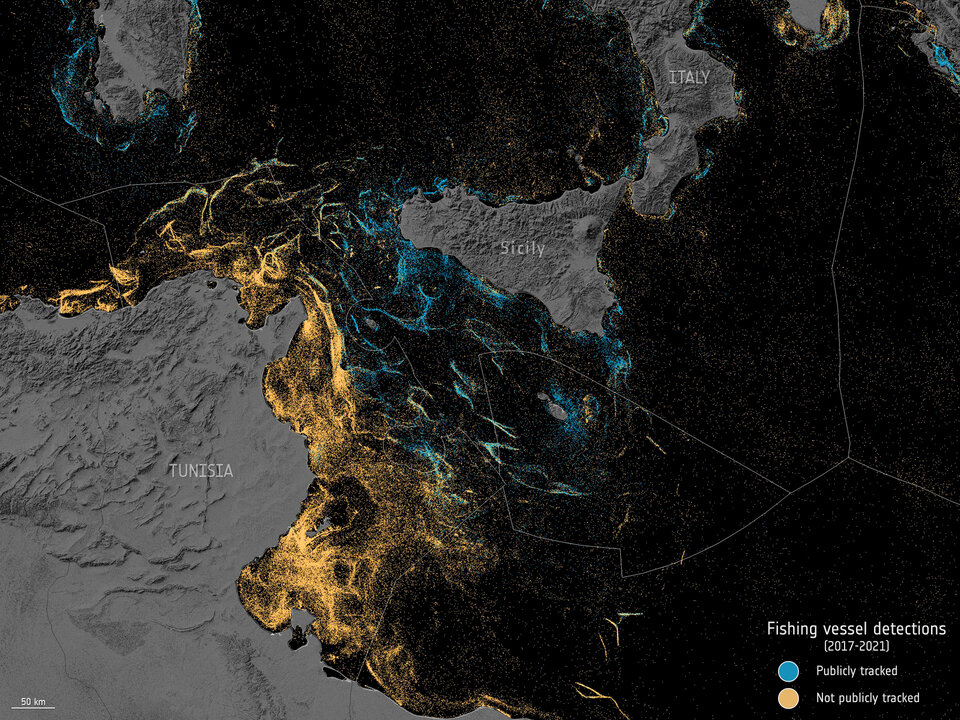
Sentinel-1D and its sister satellite Sentinel-1C both include an additional instrument called Automated Identification System (AIS), which captures signals from marine vessels in coastal areas and the Arctic. AIS devices are installed on ships and emit information such as unique identification, position, course, and speed of the ship. Ships also appear as bright objects in a dark background in Sentinel-1 radar images so their location and movements can be followed from space. By combining information on ship location with the AIS information, Sentinel-1 is a powerful tool for maritime surveillance. Applications include detecting and locating ships that might be responsible for oil spills on high seas, monitoring illegal fishing activities and/or border crossings and detecting so called ‘dark’ ships e.g. ships that have turned off their AIS to escape detection.
5. Sentinel-1 can see underneath hurricanes.

Unlike optical satellites, Sentinel-1's radar can see through the clouds of a hurricane to measure conditions on the sea surface below, including detecting the wind fields on the surface of the water. This provides unique information on the structure of the hurricane, and allows for monitoring and assessing its destructive potential, as well as providing data for emergency management and navigation that would be difficult to get from optical satellites.