Copernicus Browser guide
In brief
From above, satellites can collect data from sites around the world, including places too remote to explore in person. Through the Copernicus Data Space Ecosystem’s Copernicus Browser, you can visualise and download satellite images of almost every location you are interested in. Track environmental changes, analyse natural events, or simply explore our planet through powerful features like the comparison tool and time-lapse animation. Data is continuously updated. Have a look and try it for yourself!
In-depth
A free and easy tool to explore satellite imagery
Copernicus Browser is an online application that provides easy and free access to satellite images from the Copernicus Sentinel missions, Copernicus contributing missions and federated data sets. Built with usability in mind, the application enables anyone—from scientists and researchers to educators and the general public—to explore and analyse our planet using high-resolution satellite data. The platform provides ready-to-use satellite images, pre-configured visualisations and thematic data selections - called highlights - to support users in finding the best results. Copernicus Browser gives the option to access satellite images in multiple formats, such as true color, false color, or spectral indices like Normalized Difference Vegetation Index (NDVI), which helps monitor vegetation health. Users can also create time-lapse animations to study changes in land use, plant life, or urban growth.
Whether you’re interested in agriculture, air quality, wildfires, or volcanic activity, the Copernicus Browser can help you explore a broad spectrum of topics.

Bringing Earth observation to the classroom
The Copernicus Browser encourages interdisciplinary learning, linking areas such as climate science, sustainability, geography, computer science, and mathematics. It is a valuable addition to STEM education, supporting hands-on projects like Climate Detectives, where students investigate real-world environmental issues using satellite data.
Ready-to-use resources for educators: Copernicus Browser guide and Case Studies
The Copernicus Browser guide introduces the main tools of the Copernicus Browser and offers practical tips on using them in the classroom. As an example, the guide features a case study of the 2015 extreme drought at Lake Poopó in Bolivia—once the country's second-largest lake—which dried up dramatically, showcasing how satellite imagery can be a powerful tool to analyse environmental events.
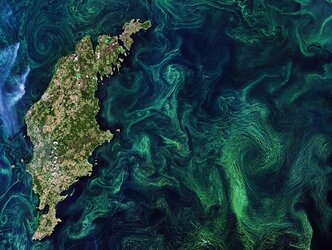
Additionally, the Copernicus Browser guide can be used alongside the Copernicus Browser Case Studies. The Copernicus Browser Case Studies serve as classroom-ready materials, giving students the chance to independently explore topics like algal blooms or oil spills. They are designed for inquiry-based Earth observation learning and come with step-by-step instructions, student worksheets, and teacher resources in English.
Access the guide here and let your students become Earth explorers with real satellite data.