• → European Space Agency

      • Space for Europe
      • Space News
      • Space in Images
      • Space in Videos
    • About Us

      • Welcome to ESA
      • DG's News and Views
      • For Member State Delegations
      • Business with ESA
      • ESA Exhibitions
      • ESA Publications
      • Careers at ESA
    • Our Activities

      • Space News
      • Observing the Earth
      • Human Spaceflight
      • Launchers
      • Navigation
      • Space Science
      • Space Engineering
      • Operations
      • Technology
      • Telecommunications & Integrated Applications
    • For Public

    • For Media

    • For Educators

    • For Kids

    • ESA

    • ESA Science

    • Mars Express

    • Europe goes to Mars

      • Europe reclaims a stake in Mars exploration
      • Space age transforms our knowledge about Mars
    • About Mars Express

      • Mars Express mission facts
      • Mars Express instruments
      • The mission
      • The spacecraft
      • The launcher
    • About Mars

      • Geography of Mars
      • Water on early Mars?
      • Signatures of life
      • Facts about Mars
    • Meet the team

      • International collaboration
      • Project Manager
      • Project Scientist
      • Mars Lead Scientist
      • Principal Investigators
      • Operations
      • Industry
    • Multimedia
    • VideoTalk
    • Mars Express images
    • Mars Express videos
    • HRSC videos
    • Animation in 11 languages
    • Download wallpapers
    • Download screensavers
    • 3D Flash 'model'
    • Make a model
    • Services
    • Comments

    ESA > Our Activities > Space Science > Mars Express

    Candor Chasma
    Perspective view of Candor Chasma, looking north-west

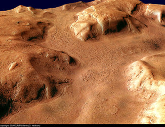
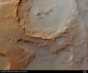
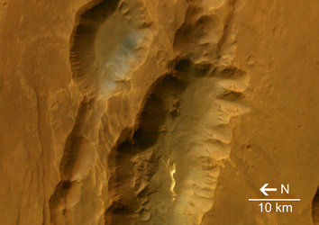
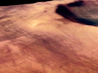
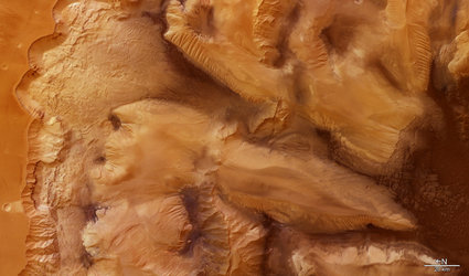
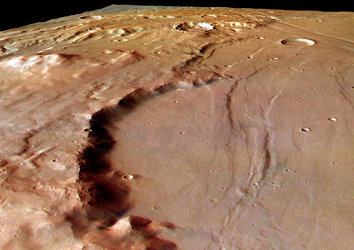
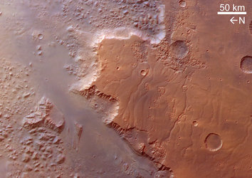
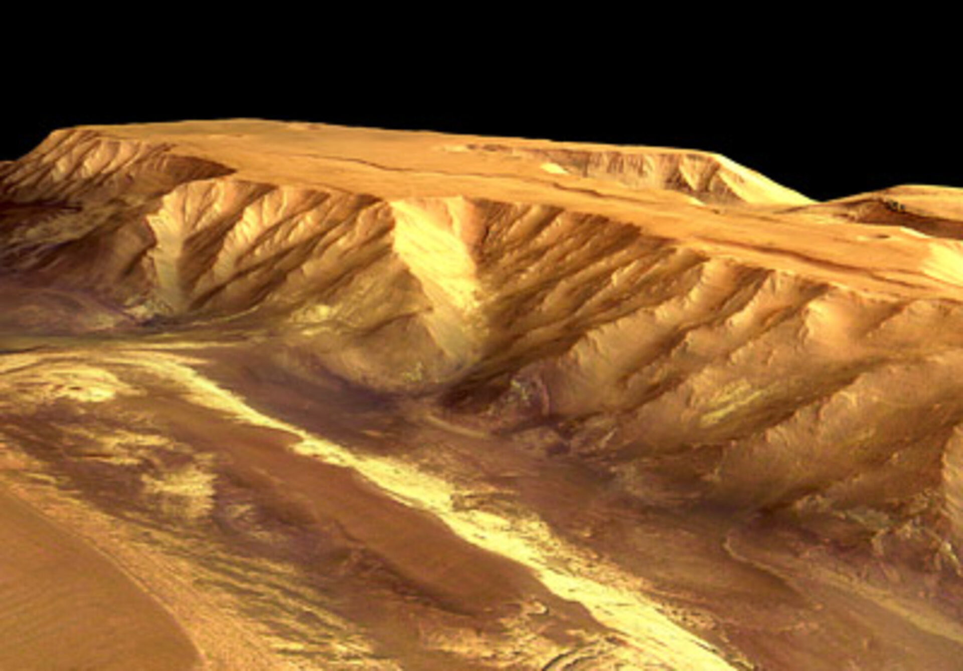
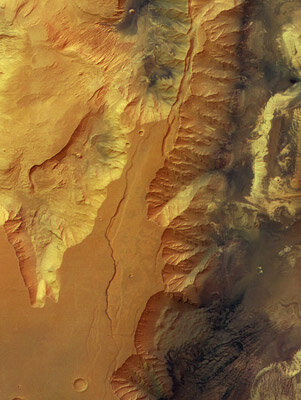
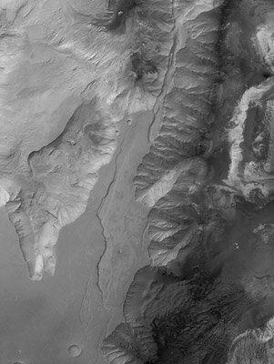
    Walls of Candor Chasma

    22 December 2004

    These images, taken by the High Resolution Stereo Camera (HRSC) on board ESA’s Mars Express spacecraft, show Candor Chasma - one of the largest canyons in the Valles Marineris canyon system.

    Candor Chasma
    Map showing Candor Chasma in context

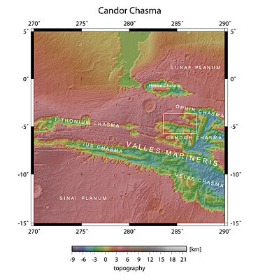
    The HRSC obtained image data in orbit 360 with a ground resolution of approximately 40 metres per pixel. The image was shows a region centred around 5° South latitude and 285° East longitude.

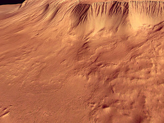
    Traces of erosion can be observed at the canyon walls, which are similar to erosional features observed on Earth in arid or alpine regions.

    The high-standing plateaus, which have an elevation of approximately six kilometres, have a very flat surface and most likely consist of several layers of basaltic lava.


    Candor Chasma in colour
    Colour view of Candor Chasma

    While it is unclear how the canyon system formed, it seems probable that tension and fracturing of the upper crust produced a widening of the canyon and subsequent lowering of the valley floor (a so-called tectonic ‘graben’).

    It is also thought that Valles Marineris could be a possible ‘rift’, which occurs when tensional fractures go deeper than the relatively elastic lithosphere (or crust).

    An alternative theory about the formation of the canyon system is the removal of rock from the subsurface material, as a result of water activity, and subsequent collapse of the surface. This process is analogous to the formation of terrestrial ‘karst’ landscapes.

    Candor Chasma
    Candor Chasma in black and white

    It could also be possible that large amounts of ice under the surface melted and this meltwater formed the large outflow channels in the north.

    As a result, the surface collapsed where substantial amounts of ice were removed, forming the Valles Marineris system as we see it today.

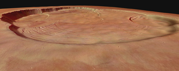
    The colour images were processed using the HRSC nadir (vertical view) and three colour channels. The perspective views were calculated from the digital terrain model derived from the stereo channels.

    Candor Chasma
    Candor Chasma in 3D

    The 3D anaglyph image was created from the nadir channel and one of the stereo channels. Stereoscopic glasses are needed to view the 3D image. Image resolution has been decreased for use on the internet.

    For more information on Mars Express HRSC images, you might like to read our updated 'Frequently Asked Questions'.

    Rate this

    Views

    Share

    • Currently 0 out of 5 Stars.
    • 1
    • 2
    • 3
    • 4
    • 5
    Rating: 0/5 (0 votes cast)

    Thank you for rating!

    You have already rated this page, you can only rate it once!

    Your rating has been changed, thanks for rating!

    185
    Tweet
    • Looking at Mars
    • Mars Express image browser
    • Recent images
      • The channels of Reull Vallis
        • Crater Hale in Argyre basin
          • Coprates Catena’s ‘collapsed’ structures
            • Martian moon Phobos in detail
              • Tithonium Chasma, Valles Marineris, on Mars
                • Rim of Crater Huygens on Mars
                  • Promethei Terra, southern highlands of Mars
                    • Ophir Chasma, part of Valles Marineris
                      • Solis Planum, Thaumasia region
                        • Eos Chasma, part of Valles Marineris
                          • Crater dunes in Argyre Planitia
                            • The eroded valleys of Dao and Niger Valles
                              • Olympus Mons caldera in perspective
                                • Escarpment and landslides of Olympus Mons
                                  • View of deposits in Melas Chasma on Mars
                                  • High Resolution Stereo Camera
                                    • Behind the lens...

    Connect with us

    • RSS
    • Youtube
    • Twitter
    • Flickr
    • G+
    • Facebook
    • Livestream
    • Subscribe
    • App Store
    • LATEST ARTICLES
    • · ESA astronaut Timothy Peake set fo…
    • · Space drives e-mobility
    • · Proba-V opens its eyes
    • · First new Galileo satellite arrive…
    • · Next destination: space
    • FAQ

    • Jobs at ESA

    • Site Map

    • Contacts

    • Terms and conditions