Implemented OSIP ideas — August 2020
ESA's Open Space Innovation Platform (OSIP) seeks novel ideas for new space research activities. Campaigns and Channels invite solutions to specific problems or ideas on more general topics, with those run by Discovery & Preparation, including the Open Discovery Ideas Channel, specifically looking for ideas that could be implemented as system studies, early technology developments, or PhD or postdoc research co-funded by ESA and a university.
In August 2020, the following ideas were implemented through the Open Discovery Ideas Channel:
| Cultural Landscapes Scanner (CLS): Earth observation and automated detection of subsoil undiscovered cultural heritage sites via AI approaches Italian Institute of Technology (IIT), Centre for Cultural heritage technology (CCHT) Sub-surface cultural heritage sites such as buried ancient structures and monuments can be discovered in remote sensing data. Using the latest breakthroughs in artificial intelligence, this research co-sponsorship activity will support the development of specific methods that automatically identify cultural heritage objects and patterns related to past human interference on landscapes. |
 |
 |
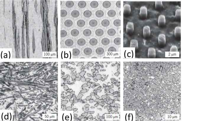
Additive manufacturing of metal matrix composites for space application (ATOM) Swiss Center for Electronics and Microtechnology (CSEM) in collaboration with the Swiss Federal Institute of Technology Lausanne (EPFL) 3D printing could be revolutionary in spacecraft design. In particular, the technique can be used to produce strong and light metal matrix composites. This research co-sponsorship project will explore the challenges that come with 3D printing metal matrix composites for space applications. |
The following ideas were implemented through the OSIP Remote Sensing of Plastic Marine Litter Campaign:
| Artificial intelligence and drones supporting the detection and mapping of floating aquatic plastic litter (AIDMAP) Carl von Ossietzky University of Oldenburg Remote detection and mapping of floating marine plastic litter from space needs to operate in synergy with clean up actions. This implies that an observation system is needed that combines high revisit time and high spatial resolution. This early technology development project will explore the use of small drones and in-situ observations combined with artificial intelligence for this purpose. |
|
 |
Detection of ocean litter plastics with hyper-to-multispectral infrared neural networks (DOLPHINN) MDA Systems Successfully mitigating the damage caused by marine litter requires large-scale, accurate mapping of ocean-borne plastics across the globe. This study aims to develop deep-learning algorithms that learn to associate multispectral data with full hyperspectral absorption features so that single multispectral images can be used to detect plastics more reliably. |
| Spectral properties of submerged and biofouled marine plastic litter The Ocean Cleanup Foundation Recent studies have shown that remote sensing of floating plastic marine litter is feasible using unmanned aerial systems, aircraft and satellite missions. However, water strongly absorbs infrared light, which makes it challenging to use this type of light to detect plastics. Additionally, marine litter is often covered with living organisms (biofouling) and it is unclear what impact this has on how they look from space. This study will explore the relationship between depth of submersion, biofouling layer and magnitude/shape of the plastic inherent spectral reflectance. |
|


 Germany
 Austria
 Belgium
 Denmark
 Spain
Spain
 Estonia
 Finland
 France
 Greece
 Hungary
 Ireland
 Italy
Italy
 Luxembourg
 Norway
 The Netherlands
 Poland
 Portugal
 Czechia
 Romania
 United Kingdom
 Slovenia
 Sweden
 Switzerland


