Applications
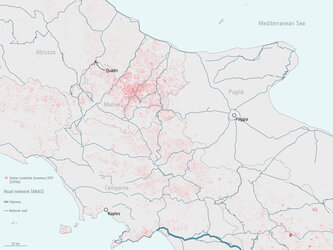
Map of the roads under direct operational management by ANAS
This map shows the roads in Italy under direct operational management by ANAS. The map shows the density of the ANAS road network is greater in the south of Italy than the north. ANAS is now using Rheticus to assess risk and adapt road designs to reduce the danger of subsequent problems for Italian motorways, tunnels and bridges. Data from ANAS road graph
Read full story: Satellite data now used for road infrastructure safety in Italy