About ESA
The European Space Agency (ESA) is Europe’s gateway to space. Its mission is to shape the development of Europe’s space capability and ensure that investment in space continues to deliver benefits to the citizens of Europe and the world.
Highlights


Latest


Space in Member States
Find out more about space activities in our 23 Member States, and understand how ESA works together with their national agencies, institutions and organisations.
 Germany
 Austria
 Belgium
 Denmark
 Spain
Spain
 Estonia
 Finland
 France
 Greece
 Hungary
 Ireland
 Italy
Italy
 Luxembourg
 Norway
 The Netherlands
 Poland
 Portugal
 Czechia
 Romania
 United Kingdom
 Slovenia
 Sweden
 Switzerland
Science & Exploration
Exploring our Solar System and unlocking the secrets of the Universe
Go to topicAstronauts


Latest


Enabling & Support
Making space accessible and developing the technologies for the future
Go to topicLatest


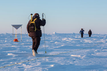
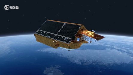
Cryo2ice for better measurements of ice, snow and polar oceans

Cryo2ice brings together two of the world’s greatest ever ice missions, ESA’s CryoSat and NASA’s ICESat-2, to gather data from each satellite over the same stretches of ice at approximately the same time.
CryoSat and ICESat-2 are the only satellite altimeters in existence measuring as far north and south as 88ᵒ and are key to our ongoing efforts to monitor the rapidly changing polar regions.
The Cryo2ice partnership began in 2020, when the CryoSat team at ESA’s mission control centre in Darmstadt, Germany performed a series of manoeuvres to bring the orbits of the two satellites closer together over the Arctic. Two years later, another tweak to CryoSat’s orbit switched the focus to Antarctica, instead.
Since the adjustment to CryoSat’s orbit, the time between collocated measurements of CryoSat and ICESat-2 has been slowly reducing, meaning that in early 2025 the two satellites will provide quasi-simultaneous measurements. It will be a boost to researchers studying sea ice, as the closer together in time between measurements, the less the sea ice will have moved, giving a more accurate snapshot of the same ice.
CryoSat’s radar and ICESat-2’s lidar both measure the elevation of sea ice and land ice by sending signals down to Earth and then detecting radar echoes and photons backscattered off the surface, but there are differences. For example, penetration of the radar and lidar signals can be different in the snowpack on top of ice. The thickness of snow on sea ice remains one of the biggest uncertainties in our estimates of ice using satellite altimetry, and Cryo2ice offers a unique opportunity to measure it more accurately.