Germany
 Austria
 Belgium
 Denmark
 Spain
Spain
 Estonia
 Finland
 France
 Greece
 Hungary
 Ireland
 Italy
Italy
 Luxembourg
 Norway
 The Netherlands
 Poland
 Portugal
 Czechia
 Romania
 United Kingdom
 Slovenia
 Sweden
 Switzerland


From satellites via the cloud to the understanding of Earth dynamics
A far-reaching European system to guarantee a better understanding of the Earth physical dynamic processes driving volcanoes, earthquakes, tsunami and the ground beneath our feet is partnering with an ESA initiative, to give solid Earth researchers easy access to an extra dimension of space data.
Some 25 European nations came together to establish the European Plate Observing System (EPOS), supported through the European Commission’s Horizon 2020 programme.
Europe as a whole is one of the world’s leading producers of Earth science data, with an extensive network of laboratories and observatories, but often valuable results gathered by national institutes are inaccessible to the largest community or made available through incompatible datasets. EPOS will allow Earth science to achieve a step change in our understanding of the planet; it will enable us to be better prepared against geo-hazards and to responsibly manage our Planet for infrastructure development, waste storage and the use of Earth’s resources.

EPOS is building up a networked scientific infrastructure to make a wide variety of geophysical information freely and easily available to users on an integrated basis. Currently being implemented, it will begin operations by the decade’s end.
The constant slow drift of the tectonic plates, moved by the internal dynamics of our planet, can result in turn to the rapid motion of earthquakes, volcanic eruptions, landslides and tsunamis. Anyone with an interest in these earth-shaking phenomena – from scientific researchers to governmental planners and decision makers to the private sector – will be free to access all relevant data through the EPOS portal.
Key EPOS data sources include seismology stations, GPS monitoring networks, volcanoes observation laboratories, regional geochemical and gravity maps, historical records, seismic hazard maps and analytical models and laboratories.
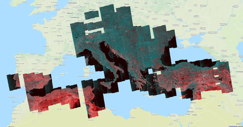
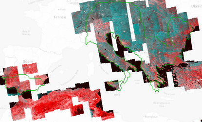
This array of ground-based resources is also being joined by the latest results from satellites in orbit, made available to EPOS through the ESA-supported ‘Geohazards Thematic Exploitation Platform’ (G-TEP) – a new, cloud-based ‘one-stop-shop’ for space-based Earth observations that can help us for a better understanding of high impact natural disasters.
“EPOS operates as a network of service platforms,” explains Salvatore Pinto, principal system architect for the TEPs at ESA. “When it came to adding a platform for satellite-based data and services for EPOS it became clear that our existing G-TEP represented a good fit.
“Satellite EO data specialists in Europe such as the CNR, University of Leeds, GFZ, CNRS and CSIC will use G-TEP as the common interface toward the main EPOS portal not only to serve EPOS users with imagery but also relevant processing and visualisation software, plus coordinating computing resources needed to work with them and extract useful knowledge.
“In return G-TEP users will have access to EPOS resources, on an interoperable basis.”

The type of space-derived products G-TEP will offer includes 2D and 3D displacement maps, seismic hazard maps, digital surface models, and time series data. While regional GPS monitoring networks can track centimetre-scale ground movement on a point-by-point basis, satellites – through a radar-based technique called ‘interferometry’ – can right go down to wide-area millimetre-scale precision.
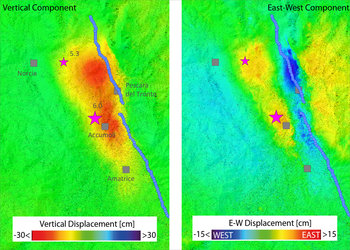
G-TEP, for instance, was used to combine imagery from Europe’s Sentinel-1A and -1B radar satellites to produce a rapid displacement map following the Amatrice earthquake in central Italy on 24 August, revealing subsidence up to 23 cm in some areas. The region is being continuously monitored with follow-up interferometry.
Satellite-derived interferometry products are used by CNR to deeply investigate the seismic events through the integration of displacement maps with in situ observations, . “This is the kind of products that we Satellite specialists want to offer to the overall European solid Earth science community“, says Michele Manunta, EO scientist from CNR and lead of the EPOS satellite activities, “which can help all of us to have a better understanding of our planet and its impact on our lives. Making all the data available in the same place and easy to access and process is the first step for this.
“In some cases, individual members of the EPOS consortium might already have access to satellite data,” adds Salvatore. “But they will be able to use them on an easier, faster and better basis with the GEP.
“In addition, EPOS will be a bridge for GEP and the overall TEP communities toward establishing collaboration with other multi-national European initiatives, with the final aim to increase uptake of space data and participate to a pan-European network of platforms for science and industry data exploitation.
GTEP is one of six Thematic Exploitation Platforms developed by ESA to serve data user communities. These cloud-based platforms provide an online environment to access information, processing tools and computing resources for collaboration. TEPs allow knowledge to be extracted from large environmental datasets produced through Europe's Copernicus programme and other Earth observation satellites.