Germany
 Austria
 Belgium
 Denmark
 Spain
Spain
 Estonia
 Finland
 France
 Greece
 Hungary
 Ireland
 Italy
Italy
 Luxembourg
 Norway
 The Netherlands
 Poland
 Portugal
 Czechia
 Romania
 United Kingdom
 Slovenia
 Sweden
 Switzerland


Tailoring satellite data for international development
International Financial Institutions (IFIs) often require detailed information about the environment to inform decision making in their development assistance activities. ESA is supporting these institutions with its Earth Observation Clinic (EO Clinic). For Earth Day 2021, we are highlighting a few EO Clinic projects contributing to international development.
ESA began working with the World Bank over ten years ago to demonstrate how satellite data can be used to support international development. Since then, the support has been extended to other institutions, including the Asian Development Bank (ADB), the International Fund for Agricultural Development (IFAD), and the Inter-American Development Bank (IDB). This has resulted in major initiatives such as EO4SD (Earth Observation for Sustainable Development) and the recently-launched SpaceforIDA (Space in support of International Development Assistance).
As the awareness of the potential of Earth observation increases, more and more small requests kept coming in, prompting ESA to set up complementary activities such as the Earth Observation Clinic (EO Clinic). Consisting of 'on-call' teams of Earth observation service suppliers and remote sensing experts, the EO Clinic is permanently poised to support development banks and agencies interested in understanding the added value of Earth observation data and services.
"The idea behind the EO Clinic is to answer quick turnaround requests from development professionals to test and transform Earth observation data into a more analytical product useful for decision making," explains EO Clinic coordinator, Zoltan Bartalis.
"This detailed environmental data can be combined with the partners' own datasets, including socio-economic information on employment, health, education, the economy and much more, to help development projects achieve their ambitious goals."
The EO Clinic is available to most IFIs and bilateral aid agencies. So far, projects have been conducted with the World Bank, the ADB, the United Nations Development Programme (UNDP) and the Deutsche Gesellschaft für Internationale Zusammenarbeit (GIZ).
UNDP – Characterising forest ecosystems in Armenia
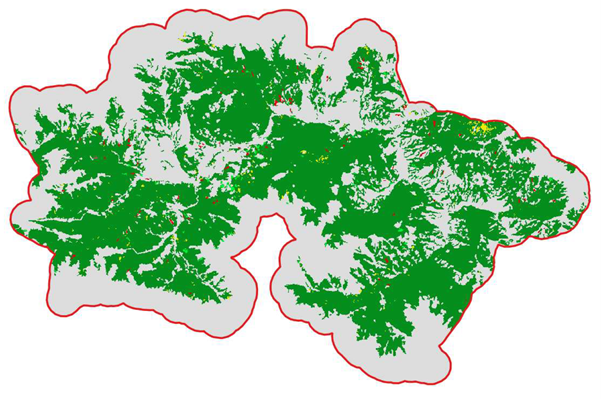
Located at a junction where three biogeographic regions meet, Armenia boasts a diverse range of landscapes, climates and ecology, with distinct and sometimes rare flora and fauna. Dilijan National Park is renowned in particular for its dense forest, rich biodiversity, medicinal springs, natural and cultural monuments and extensive network of hiking trails. Despite this, the park is under threat from a dense human population living there, developing infrastructure, uncontrolled tourism, illegal logging, poaching and the unsustainable use of natural resources.
To support the Armenian government in its ambitions to rehabilitate degraded forest and increase forest cover, UNDP's Armenia office is seeking to better understand the past socio-environmental processes that impact the sustainable management of forest resources, including changes in land cover and land use.
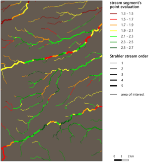
In 2020, UNDP Armenia requested assistance from the EO Clinic to provide the environmental information needed to support forest management in the Dilijan region. Using Earth observation data, EO Clinic service providers GeoVille (Austria) and SIRS/CLS (France) developed a tool to characterise forest ecosystems and their evolution in the Dilijan National Park in the form of maps of land use and land cover for 1991–2019. The project also delivered detailed information on forest density and class, which could be used to assess and locate deforestation or forest degradation.
GIZ – Strengthening drought resilience in Ethiopia
The majority of the seven million inhabitants of the Afar and Somali regions of Ethiopia are livestock farmers and depend on semi-mobile livestock for their livelihoods. But their economic and social systems are under pressure due to population growth and the impact of climate change, which is linked to increasing frequency and severity of droughts and floods.
In collaboration with the Ethiopian Ministry of Agriculture, GIZ has developed a programme to strengthen drought resilience and help local people deal with this situation. One of the aims is to rehabilitate degraded water catchment areas and pasture areas in dry valleys.
In 2020, EO Clinic service providers everis (Spain), GREENSPIN (Germany) and World from Space (Czech Republic) supported GIZ and its Ethiopian partners by providing information derived from satellite data that could be used to prioritise and select intervention sites. The team delivered Earth observation mapping products on riverbed locations, soil type, agricultural cultivation, road networks, settlements, and more, using a series of global and local datasets. The ultimate aim was to support GIZ Ethiopia and its partners in their selection of sites for the construction of weirs – small dams built across rivers to control the upstream water level.
World Bank – Natural wealth and sovereign risk

Monitoring crop growth and health across many different countries is valuable for the financial sector (for example, for commodity trading) as well as for policymakers.
The World Bank's Global Program on Sustainability is looking beyond traditional financial metrics to account for environmental risks and opportunities, as well as valuing natural capital and ecosystem services. As part of this ambition, the World Bank launched the Environmental, Social and Governance data portal in 2019.
But the environmental data available to the World Bank is usually inconsistent, not sufficiently granular and not available with a high enough frequency. It is also very difficult to compare with wealth data available only at a country level and on an annual frequency.
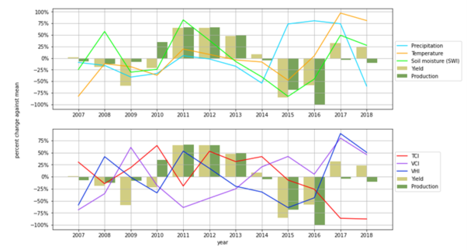
In 2020, an EO Clinic project supported the World Bank by providing maps and statistics of crop types in several countries that could be used for cross-country comparison. The project team also provided information on crop health that can serve as a foundation for a global crop monitoring system. The data provided was not only more detailed than what the World Bank previously had access to, but also objective and globally consistent, making it a valuable addition to the Bank's resources.
ADB – Safe drinking water for West Bengal

With some groundwater in India being contaminated with arsenic, fluoride or salt, around 27 million people are at risk of arsenic or fluoride poisoning. This can cause a range of health issues, including cancer and bone diseases, and the issue is particularly serious in the state of West Bengal.
The ADB is working with the Indian government to provide safe and sustainable drinking water to 1.65 million people in West Bengal. The Bank has explored several ways to do this; one shortlisted solution falls under the Nature-Based Solutions approach, with the aim to improve the storage of floodwater using inactive river channels along the Rupnarayan River. Some channels carry water only during the monsoon season, so during the dry season they could provide a suitable water storage solution.
However, the ADB and its partners have no comprehensive overview of the availability of potential water storage sites in the target area. The EO Clinic recently stepped in to provide such an inventory of suitable sites.
The inventory is being built by EO Clinic service providers everis (Spain), IHCantabria (Spain) and i-Sea (France) by combining maps of surface water bodies and their dynamics – including the seasonal changes in their extent – with the latest information on land use and land cover for the surroundings of the identified seasonal water areas.
World Bank – Informal trade in Central Asia
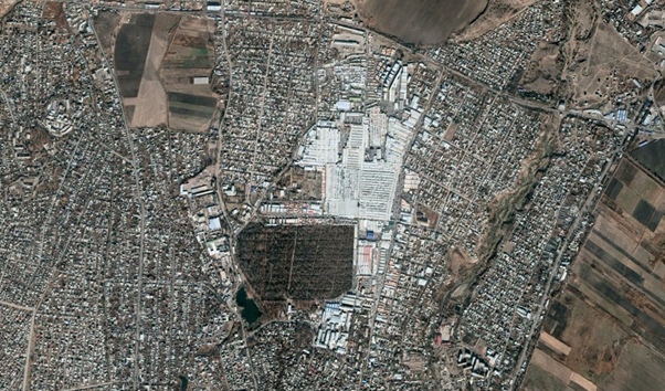
In Central Asia, a huge amount of informal trade takes place, usually involving undeclared activities across borders, in markets or bazaars. Although this 'shadow economy' provides significant employment opportunities, it is generally not recorded in official statistics and hurts law-abiding local firms that compete with undeclared goods.
The World Bank is helping to improve regional trade integration in Central Asia; part of this involves capturing the size of the informal trading sector, which could result in a leap forward in designing policies for border compliance and fiscal management.
An EO Clinic team consisting of e-Geos (Italy), GAF (Germany) and Planetek Italia (Italy) is currently supporting the World Bank efforts by investigating how remote sensing methods can be used to observe inland bazaars in order to directly or indirectly estimate current and past informal trade. These novel Earth observation methods are detecting changes in the physical environment of the bazaars, for example counting vehicles in parking lots to estimate retailer revenues.
To discover more examples of how Earth observation data supports international development, read about the other projects on the EO Clinic webpage.