
Multi-Beam Fast Scanning Radar Altimeter
| 765 - Abstract: |
| The present invention proposes a novel Radar Altimeter to measure sea surface height over a wide swath (>120km), flying on a Low Earth Orbit (LEO). This technique employs a single Rx phased-array antenna and carries out very fast scanning of Rx beams in the direction opposite of the radar pulse travelling on-ground. ESA is looking for partners who would be interested in licensing and implementing this patent. |
Description:
Satellite altimetry, supplying continuous worldwide observations of the sea surface height, has been increasing science’s knowledge of ocean circulation since the 1978 Seasat mission.
The ocean is a turbulent environment, where, in particular, ‘mesoscale’ eddies (i.e., eddies of about 50 to 500 km across) are generated and move across the ocean. The goal of operational oceanography is to describe such ocean dynamics in real-time and to provide forecasts. Altimetry typically supplies the most important data for these purposes.
The capability to observe sea surface height over a large swath from a single satellite would be a key enabler for sampling the mesoscale ocean dynamics on adequate spatial and temporal scales. Conventional radar altimeters observe the ocean on a single footprint in nadir direction, and as such are not able to provide high spatial-temporal sampling of the ocean surface. Radar interferometry can be employed to achieve topography over a wide-swath, but it requires the use of multiple Rx antennas placed at moderate-to-large distances (baseline length in the order of metres).
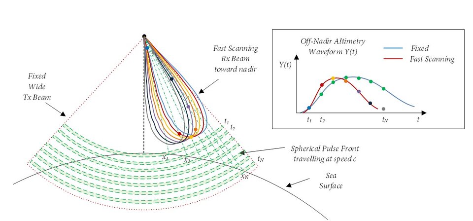
To overcome this limitation, a new method of performing satellite-based radar altimetry which is capable of measuring sea surface height over a wide swath in the across-track direction, employing a single Rx phased-array antenna, is presented. This method is illustrated in Figure 1 and described as follows:
A radar pulse (which could be one among a sequence of periodically emitted radar pulses) is emitted towards the ocean surface by a Tx antenna, placed on a LEO satellite, in a first wide beam, covering the entire swath. After reflection off the ocean surface an echo of the radar pulse is received a phased-array Rx antenna forming a scanning beam (Tx and Rx antennas can also be combined).
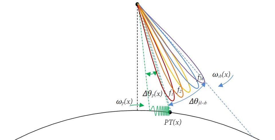
The Rx beam is scanned with a scanning motion in a scanning direction orthogonal to a ground track of the satellite (a sweep with the beam is performed) towards nadir. The scanning of the Rx beam is carried out at very high speed, typically at order of magnitudes greater than the speed of the pulse travelling along the Earth surface in opposite direction. This allows the formation of a very sharp altimetry waveform, receiving the reflected echo from a very narrow across-track region. Multiple sequential Rx scanning beams are thus employed in order to form as many altimetry waveforms while the radar echo pulse travels across the wanted swath. The invention also proposes to apply a frequency dependent pointing in order to allow full range compression of the radar pulse without compromising the scanning speed. Finally, the estimation of time of reception of the altimetry waveform, in combination with the knowledge of the pointing of the Rx beam (known from instrument on-board timing), allows the estimation of the sea surface height.
Innovations and advantages:
- One antenna only on Rx => Can be rather compact, big advantage in size/mass with respect to conventional techniques.
- Very large swath above 120km achievable.
- Moderate Tx Power needed.
- Extension of the classical altimetry concept, so strong re-use of existing processing algorithms and traceability with previous missions is much easier with regards to interferometric processing -> great cross calibration/validation possibilities with legacy altimeters.
- The proposed wide swath altimeter embeds also a classical altimeter so there is full traceability with the legacy radar altimeters.
- No need to transmit sequentially to left and right swath, both swaths are illuminated with the same pulse.
- Easy extension to increase PRF and to discriminate simultaneous pulses with multiple beams. No need of extra HW for this, while the interferometric would need extra separate LNA and RF chains in order to generate the extra beams.
- It gives flexibility in selecting different operative modes, i.e. scanning speed, in order to look for specific geophysical properties such as swells.
Domain of application:
Radar Altimeters are among the radar instruments with large flight heritage, widely employed since at least 3 decades. Next generation spaceborne radar altimeters are required to provide very high sea surface height accuracy over wide swaths. The proposed invention covers this need with an innovative concept.
Development areas can include:
- Instrument Development: Rx array antenna, Rx DBF, Instrument processing
- Instrument On-ground processing: processing/retrieval algorithms
This technique could also be possibly used for airborne altimetry.